IMAGES TAKEN NEAR TO
Keyhaven Road, LYMINGTON, SO41 0QX
Introduction
This page details the photographs taken nearby to Keyhaven Road, SO41 0QX by members of the Geograph project.
The Geograph project started in 2005 with the aim of publishing, organising and preserving representative images for every square kilometre of Great Britain, Ireland and the Isle of Man.

There are currently over 7.5m images from over14,400 individuals and you can help contribute to the project by visiting https://www.geograph.org.uk
Image Map
Images are licensed for reuse under creativecommons.org/licenses/by-sa/2.0
Notes
- Clicking on the map will re-center to the selected point.
- The higher the marker number, the further away the image location is from the centre of the postcode.
Image Listing (27 Images Found)
Images are licensed for reuse under creativecommons.org/licenses/by-sa/2.0
Image
Details
Distance
1
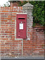
Milford on Sea: postbox № SO41 65, Keyhaven Road
This George VI-reign postbox is set into a brick wall - actually at the join between two brick walls - and is emptied finally at 4:45pm on weekdays and at 9:45am on Saturdays.
Image: © Chris Downer
Taken: 11 Jun 2011
0.02 miles
3
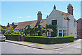
Carrington Farm House
This original farm house, now a bed & breakfast establishment, dates from the early 14th Century, although parts originate from a 10th Century building recorded in the Domesday Book. The ‘new extension’ (on the right) was added in 1888.
Up until thirty-five years ago it was still a working farm with a bull shed, now the Cottage, and milking sheds, now self-contained rooms which form part of the adjoining September Cottage.
Image: © mike smith
Taken: 25 May 2011
0.10 miles
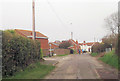
4
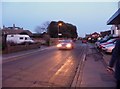
Milford on Sea : Keyhaven Road
This short road, which had a few potholes, connects Milford on Sea with the inlet of Keyhaven.
Image: © Lewis Clarke
Taken: 17 Feb 2010
0.14 miles
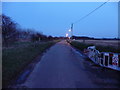
5
Milford on Sea : Keyhaven Road
Walking along Keyhave Road as it gets dark at 5:45pm.
Image: © Lewis Clarke
Taken: 17 Feb 2010
0.15 miles
6
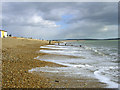
East end of Milford-on-Sea beach
Looking east along the beach from the edge of the grid square, with the shingle bank of Hurst Beach in the distance and the Isle of Wight on the horizon.
Image: © Jim Champion
Taken: 12 Mar 2005
0.16 miles
8
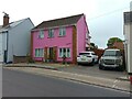
The Pink House, Milford on Sea
A bright pink house on Keyhaven Road in Milford on Sea.
Image: © Oscar Taylor
Taken: 24 Jun 2023
0.19 miles
9
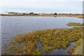
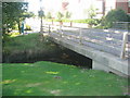
Northern End of Sturt Pond
This pond, adjacent to the sea, is a haven for water fowl and other birds.
Image: © mike smith
Taken: 23 Nov 2011
0.19 miles
10
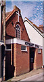
Milford-on-Sea Methodist Church
Erected in 1911 for the Baptists. Became Methodist in 1959.
Image: © Michael FORD
Taken: Unknown
0.19 miles