IMAGES TAKEN NEAR TO
Elizabeth Crescent, LYMINGTON, SO41 0HP
Introduction
This page details the photographs taken nearby to Elizabeth Crescent, SO41 0HP by members of the Geograph project.
The Geograph project started in 2005 with the aim of publishing, organising and preserving representative images for every square kilometre of Great Britain, Ireland and the Isle of Man.

There are currently over 7.5m images from over14,400 individuals and you can help contribute to the project by visiting https://www.geograph.org.uk
Image Map
Images are licensed for reuse under creativecommons.org/licenses/by-sa/2.0
Notes
- Clicking on the map will re-center to the selected point.
- The higher the marker number, the further away the image location is from the centre of the postcode.
Image Listing (43 Images Found)
Images are licensed for reuse under creativecommons.org/licenses/by-sa/2.0
Image
Details
Distance
1
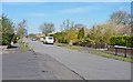
Longfield Road
This is one of several residential roads in a rectangular development to the south of Hordle.
Image: © mike smith
Taken: 13 Apr 2012
0.05 miles
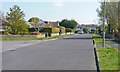
2

Berryfield Road
This is one of several residential roads in a rectangular development to the south of Hordle.
Image: © mike smith
Taken: 13 Apr 2012
0.08 miles
3
Pegasus Avenue
This is one of several residential roads in a rectangular development to the south of Hordle.
Image: © mike smith
Taken: 13 Apr 2012
0.08 miles
4
Everton Road Footpath Hordle
Linking the main road to a number of side streets.
Image: © Anthony Vosper
Taken: 23 Aug 2013
0.11 miles
5
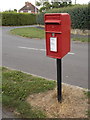
Hordle: postbox № SO41 190, Pegasus Avenue
An ordinary Elizabeth II-reign postbox close to the junction with the more major Vicarage Lane, which we see in the background.
Image: © Chris Downer
Taken: 26 Aug 2013
0.13 miles
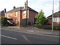
6
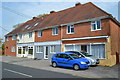
Former shops in Everton Road, Hordle
The last of these seems to have been the one on the right, still visible in 2016 Google Streetview imagery as "Owen A Worboys, Motor Engineer"
Image: © David Martin
Taken: 8 Apr 2019
0.15 miles
8
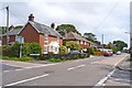
Everton Road, Hordle
This is looking south east from the junction with Hordle Lane
Image: © mike smith
Taken: 16 Jun 2012
0.16 miles
9

Hordle: postbox № SO41 89, Everton Road
A George VI-reign postbox facing the frontage of a row of four shops, only one of which (a motor engineer) is still operating.
Image: © Chris Downer
Taken: 26 Aug 2013
0.16 miles