IMAGES TAKEN NEAR TO
Cherrywood Gardens, SOUTHAMPTON, SO40 8FZ
Introduction
This page details the photographs taken nearby to Cherrywood Gardens, SO40 8FZ by members of the Geograph project.
The Geograph project started in 2005 with the aim of publishing, organising and preserving representative images for every square kilometre of Great Britain, Ireland and the Isle of Man.

There are currently over 7.5m images from over14,400 individuals and you can help contribute to the project by visiting https://www.geograph.org.uk
Image Map
Images are licensed for reuse under creativecommons.org/licenses/by-sa/2.0
Notes
- Clicking on the map will re-center to the selected point.
- The higher the marker number, the further away the image location is from the centre of the postcode.
Image Listing (14 Images Found)
Images are licensed for reuse under creativecommons.org/licenses/by-sa/2.0
Image
Details
Distance
2
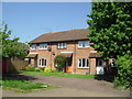
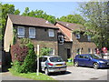
Nickleby Gardens
1990s houses in Totton.
Image: © Burgess Von Thunen
Taken: 22 May 2012
0.11 miles
5
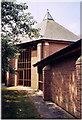
Trinity Church, Totton
Erected in 1991 by both the Methodist Church (formerly in Ringwood Road, Totton, now Totton Christian Centre) and the United Reformed Church (formerly in Bartram Road, now Hayes music shop) as an Ecumenical Church Partnership who formally joined as "Trinity church" in the late '80s (possibly 1987) prior to the agreement to move to the new location in the early '90s.
Image: © Michael FORD
Taken: Unknown
0.16 miles
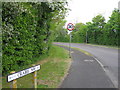
6
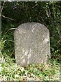
Old Milestone by the A336, Ringwood Road, Netley Marsh Parish
Carved stone post by the A336, in parish of NETLEY MARSH (NEW FOREST District), West of junction of Crabbs Way with Ringwood Road, by the road, on North side of road. Soton stone, erected by the Sarum & Eling turnpike trust in the 19th century.
Inscription reads:- : S(outhampton) / (6) : : (Fordingbridge) / (13) :
Milestone Society National ID: HA_SOLD06.
Image: © K Lawrence
Taken: 7 Dec 2003
0.16 miles
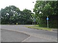
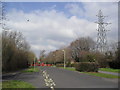
7
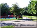
Cycle path and play area, Hazel Farm
This extensive area of housing is served by a network of paths, separating pedestrians and cyclists from vehicle traffic
Image: © David Martin
Taken: 13 Jun 2010
0.16 miles
8
Rufus Gardens
1990s flats in Totton.
Image: © Burgess Von Thunen
Taken: 22 May 2012
0.17 miles
9
Hazel Farm Road
Outside Hazel Wood Infant School in Totton.
Image: © Burgess Von Thunen
Taken: 21 Mar 2012
0.17 miles
10
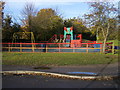
Hazel Farm North play area
Brightly coloured Hazel Farm North children's play area
Image: © Shaun Ferguson
Taken: 7 Nov 2008
0.18 miles