IMAGES TAKEN NEAR TO
Stirling Crescent, SOUTHAMPTON, SO40 3BP
Introduction
This page details the photographs taken nearby to Stirling Crescent, SO40 3BP by members of the Geograph project.
The Geograph project started in 2005 with the aim of publishing, organising and preserving representative images for every square kilometre of Great Britain, Ireland and the Isle of Man.

There are currently over 7.5m images from over14,400 individuals and you can help contribute to the project by visiting https://www.geograph.org.uk
Image Map
Images are licensed for reuse under creativecommons.org/licenses/by-sa/2.0
Notes
- Clicking on the map will re-center to the selected point.
- The higher the marker number, the further away the image location is from the centre of the postcode.
Image Listing (28 Images Found)
Images are licensed for reuse under creativecommons.org/licenses/by-sa/2.0
Image
Details
Distance
1
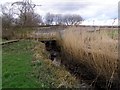
Birdwatching hide, Lower Test nature reserve
Viewed from the boardwalk, this is an open-air birdwatching hide constructed by the Hampshire and Isle of Wight Wildlife trust. It looks out over the Test estuary marshes and reed beds.
Image: © Jim Champion
Taken: 25 Feb 2007
0.04 miles
2
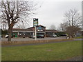
Testwood: the Salmon Leap
A neighbourhood pub literally on the edge of the suburbs of Totton, straddling the gridline between this square and the next one south.
Image: © Chris Downer
Taken: 29 Feb 2016
0.06 miles
3
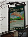
Testwood: the Salmon Leap pub sign
A close-up of the sign for Image], pictured appropriately on the Leap Day.
Image: © Chris Downer
Taken: 29 Feb 2016
0.07 miles
4
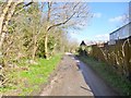
Totton, Test Way
Long-distance footpath - this section from Totton to Romsey: http://www3.hants.gov.uk/longdistance/testway.htm
Image: © Mike Faherty
Taken: 1 Mar 2014
0.08 miles
5
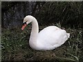
Swan, Lower Test nature reserve
This swan was sitting alongside the boardwalk between the birdwatching hides on the western side of the Lower Test Nature Reserve. Approaching the mating season the birds get aggressive over territory - this one looks as if it had been in a fight.
Image: © Jim Champion
Taken: 25 Feb 2007
0.08 miles
6
The Test Way leaving Totton
The way takes the lane to the right of the car. Ahead, on the left, is the 18th century lodge to the formed Testwood House estate, possibly designed by Capability Brown https://historicengland.org.uk/listing/the-list/list-entry/1259414?section=official-list-entry
Image: © Tim Heaton
Taken: 9 Oct 2023
0.09 miles
7
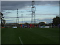
Testwood Park - AFC Totton
The view looks beyond the east of the ground to Southampton via many pylons and the now narrowing River Test. Totton in blue were playing Abingdon Utd in red. Incidentally, this is the friendliest crowd I have ever been in!
Image: © nick macneill
Taken: 18 Oct 2008
0.09 miles
8
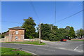
Former gatehouse of Great Testwood House
The Grade II listed gatehouse stands at one portal of an ovoid driveway. When we were children the vestiges of the lower walls of the big house were visible, due north of this building. However my father, who knew the area before WW2, says that the house was demolished well before that war. The gatehouse is mid to late 18th C, possibly by Capability Brown. It has English Heritage Building ID: 462918. See also: http://www.britishlistedbuildings.co.uk/en-462918-great-testwood-lodge-90-totton-and-eling
Image: © Stuart Logan
Taken: 7 May 2012
0.09 miles
9
Totton, nature reserve
Lower Test Nature Reserve, administered by Hampshire Wildlife Trust. According to an interpretation board, one of the largest reedbeds in southern England: http://www.hiwwt.org.uk/pages/lower-test.html
Image: © Mike Faherty
Taken: 1 Mar 2014
0.10 miles
10
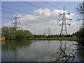
Test Way, Power Lines
These power lines are in the Lower Test Nature Reserve
Image: © Adrian King
Taken: 29 Apr 2006
0.11 miles