IMAGES TAKEN NEAR TO
Kent Gardens, SOUTHAMPTON, SO40 2QP
Introduction
This page details the photographs taken nearby to Kent Gardens, SO40 2QP by members of the Geograph project.
The Geograph project started in 2005 with the aim of publishing, organising and preserving representative images for every square kilometre of Great Britain, Ireland and the Isle of Man.

There are currently over 7.5m images from over14,400 individuals and you can help contribute to the project by visiting https://www.geograph.org.uk
Image Map
Images are licensed for reuse under creativecommons.org/licenses/by-sa/2.0
Notes
- Clicking on the map will re-center to the selected point.
- The higher the marker number, the further away the image location is from the centre of the postcode.
Image Listing (8 Images Found)
Images are licensed for reuse under creativecommons.org/licenses/by-sa/2.0
Image
Details
Distance
1
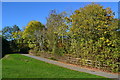
Path to railway footbridge
Definitely signs of autumn here.
Image: © David Martin
Taken: 21 Oct 2018
0.02 miles
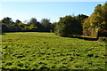
2

Bournemouth to Southampton railway line
Taken from a footbridge on the cycle path from Rushington to Testwood. In the very far distance, as the track begins to curve out of sight the Fawley Branch Line diverges to the right of this view - the junction is in the adjacent 1km square.
Image: © David Martin
Taken: 13 Jun 2010
0.05 miles
6
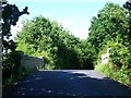
Bridge carrying Rushington Lane over railway
Image: © David Martin
Taken: 13 Jun 2010
0.17 miles
7
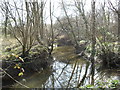
Bartley Water
A stream in the woods behind Rowan Close.
Image: © Burgess Von Thunen
Taken: 21 Mar 2012
0.19 miles
8
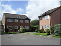
Hudson Court
1990s houses in Totton.
Image: © Burgess Von Thunen
Taken: 2 Aug 2012
0.24 miles