IMAGES TAKEN NEAR TO
Vicarage Lane, SOUTHAMPTON, SO40 2PA
Introduction
This page details the photographs taken nearby to Vicarage Lane, SO40 2PA by members of the Geograph project.
The Geograph project started in 2005 with the aim of publishing, organising and preserving representative images for every square kilometre of Great Britain, Ireland and the Isle of Man.

There are currently over 7.5m images from over14,400 individuals and you can help contribute to the project by visiting https://www.geograph.org.uk
Image Map
Images are licensed for reuse under creativecommons.org/licenses/by-sa/2.0
Notes
- Clicking on the map will re-center to the selected point.
- The higher the marker number, the further away the image location is from the centre of the postcode.
Image Listing (50 Images Found)
Images are licensed for reuse under creativecommons.org/licenses/by-sa/2.0
Image
Details
Distance
1
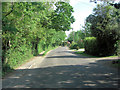
Pollards Moor Road, east of Pollards Moor Farm
Image: © Stuart Logan
Taken: 30 May 2012
0.13 miles
2

St Mary's Church Tower and Clock at Copythorne
Image: © Val Pollard
Taken: 22 Feb 2003
0.13 miles
7
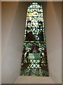
Stained glass window, St Mary Copythorne
Image: © Basher Eyre
Taken: 24 Sep 2011
0.17 miles
10
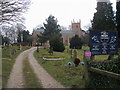
St Mary Copythorne
Drive up to St Mary church Copythorne
Image: © Shaun Ferguson
Taken: 29 Jan 2009
0.17 miles