IMAGES TAKEN NEAR TO
Pegasus Close, SOUTHAMPTON, SO31 4QZ
Introduction
This page details the photographs taken nearby to Pegasus Close, SO31 4QZ by members of the Geograph project.
The Geograph project started in 2005 with the aim of publishing, organising and preserving representative images for every square kilometre of Great Britain, Ireland and the Isle of Man.

There are currently over 7.5m images from over14,400 individuals and you can help contribute to the project by visiting https://www.geograph.org.uk
Image Map
Images are licensed for reuse under creativecommons.org/licenses/by-sa/2.0
Notes
- Clicking on the map will re-center to the selected point.
- The higher the marker number, the further away the image location is from the centre of the postcode.
Image Listing (162 Images Found)
Images are licensed for reuse under creativecommons.org/licenses/by-sa/2.0
Image
Details
Distance
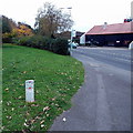
1
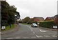
Spitfire Way, Hamble-le-Rice
Viewed from Hamble Lane looking past a damaged car towards the right turn for Cirrus Gardens.
Image: © Jaggery
Taken: 17 Nov 2013
0.04 miles
2
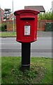
Elizabeth II postbox on Aquila Way
Postbox No. S031 257.
Image: © JThomas
Taken: 27 Apr 2022
0.04 miles
3
Elizabeth II postbox on Aquila Way
Showing position of Postbox No. S031 257.
Image: © JThomas
Taken: 27 Apr 2022
0.04 miles
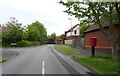
6
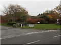
Corner of Aquila Way and Hamble Lane, Hamble-le-Rice
A large name sign shows the various streets that can be accessed via Aquila Way on the left.
On the right is a tribute to the Air Transport Auxiliary. http://www.geograph.org.uk/photo/3814629
Image: © Jaggery
Taken: 17 Nov 2013
0.05 miles
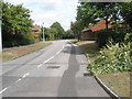
7
Disused level crossing, Barton Drive
The disused private branch from near Hamble station to an oil installation (currently BP Oil) on Southampton Water crosses here. The track still seems mostly in place but it is heavily overgrown. Double tracks here, a loop on the single line. The white pipeline markers explain why the railway fell out of use.
Image: © Robin Webster
Taken: 28 Dec 2014
0.06 miles
8
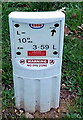
Esso No Dig Zone marker, Hamble-le-Rice
The marker giving details of an underground pipe is located here. http://www.geograph.org.uk/photo/3814665
Image: © Jaggery
Taken: 17 Nov 2013
0.06 miles
9
Esso No Dig Zone marker, Hamble-le-Rice
Located near the fire station. http://www.geograph.org.uk/photo/3748035
http://www.geograph.org.uk/photo/3814660 to a closeup view of the marker.
Image: © Jaggery
Taken: 17 Nov 2013
0.06 miles
10
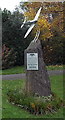
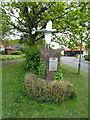
Air Transport Auxiliary tribute in Hamble-le-Rice
Located here http://www.geograph.org.uk/photo/3814606 at what used to be the entrance to Hamble-le-Rice Airfield and to the Air Transport Auxiliary (ATA) Ferry Pool. Unveiled on July 10th 2010, the 70th anniversary of the Battle of Britain, the tribute shows the badge of the ATA and its motto AETHERIS AVIDI (eager for the air).
The text records that the ATA was formed at the outbreak of war in September 1939 to transport mail, dispatches and essential supplies. It quickly developed to ferry new, damaged and repaired aircraft between the aviation industry and the RAF and Fleet Air Arm airfields. The ATA delivered all types of newly built operational aircraft and flew others in need of repair. Between September 1939 and November 1945 the ATA flew 309,011 aircraft missions.
The fledgling ATA consisted of just a few dozen men, with eight women joining shortly after. The wartime strength of ATA pilots was in excess of 1200, including 168 women. It employed able bodied and disabled people from 28 countries. They all performed the same duties, and they all received equal pay and rights. Tragically 173 ATA personnel were killed on duty.
Image: © Jaggery
Taken: 17 Nov 2013
0.06 miles