IMAGES TAKEN NEAR TO
Blundell Lane, SOUTHAMPTON, SO31 1AA
Introduction
This page details the photographs taken nearby to Blundell Lane, SO31 1AA by members of the Geograph project.
The Geograph project started in 2005 with the aim of publishing, organising and preserving representative images for every square kilometre of Great Britain, Ireland and the Isle of Man.

There are currently over 7.5m images from over14,400 individuals and you can help contribute to the project by visiting https://www.geograph.org.uk
Image Map
Images are licensed for reuse under creativecommons.org/licenses/by-sa/2.0
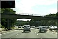
Notes
- Clicking on the map will re-center to the selected point.
- The higher the marker number, the further away the image location is from the centre of the postcode.
Image Listing (12 Images Found)
Images are licensed for reuse under creativecommons.org/licenses/by-sa/2.0
Image
Details
Distance
1
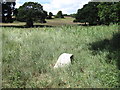
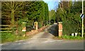
Manor Farm Country Park
The stone is inscribed Botley and Bursledon on opposite sides and 1900 on the top
Image: © Chris Wimbush
Taken: 9 Aug 2010
0.18 miles
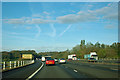
2
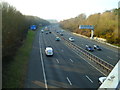
The M27 looking west from Blundell Lane
In the distance is the bridge carrying Dodwell Lane which is in the next grid square to the west.
Image: © Shazz
Taken: 12 Mar 2012
0.19 miles

6
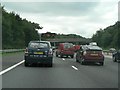
?Incident ? slow down, 40?
The matrix sign was flickering at a slower speed than my camera's shutter was open, hence it has come out illegibly in this image. It says "Incident – slow down" followed by a large "40", which is added insult when you have just accelerated to about 3mph!
This afternoon a body ("thought to be that of a woman" according to this news site: http://www.dailyecho.co.uk/mostpopular.var.1654527.mostviewed.motorway_reopened_following_death_earlier_today.php ) was found on the M27, causing havoc on the motorway – and on surrounding roads as drivers sought alternative routes. Arriving here at about 4:10p.m., and having come off the motorway at the next junction it took me 1½ hours to rejoin it, beyond the incident, about 6 miles further on.
Image: © Chris Downer
Taken: 30 Aug 2007
0.20 miles
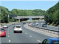
8
M27 west approaching Dodwell lane bridge
Just prior to Junction 8
Image: © John Firth
Taken: 17 Mar 2012
0.23 miles
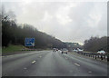
9
M27 crossing River Hamble
The brown tourist sign advises the way to Royal Victoria and Manor Farm country parks.
Image: © Robin Webster
Taken: 30 Oct 2012
0.24 miles