IMAGES TAKEN NEAR TO
Westfield Drove, ALRESFORD, SO24 0FE
Introduction
This page details the photographs taken nearby to Westfield Drove, SO24 0FE by members of the Geograph project.
The Geograph project started in 2005 with the aim of publishing, organising and preserving representative images for every square kilometre of Great Britain, Ireland and the Isle of Man.

There are currently over 7.5m images from over14,400 individuals and you can help contribute to the project by visiting https://www.geograph.org.uk
Image Map
Images are licensed for reuse under creativecommons.org/licenses/by-sa/2.0
Notes
- Clicking on the map will re-center to the selected point.
- The higher the marker number, the further away the image location is from the centre of the postcode.
Image Listing (6 Images Found)
Images are licensed for reuse under creativecommons.org/licenses/by-sa/2.0
Image
Details
Distance
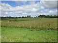
1
Alongside Westfield Drove
Hamilton Farm Cottages are hidden by the trees.
Image: © Jonathan Thacker
Taken: 4 Aug 2017
0.01 miles
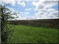
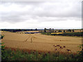
2
Bean field and Rabbit Copse
Rabbit Copse in the distance on the right.
Image: © Jonathan Thacker
Taken: 4 Aug 2017
0.07 miles
3
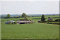
Hamilton Farm, Beauworth
Seen from Holden Lane.
Image: © Peter Facey
Taken: 26 May 2013
0.10 miles
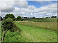
4
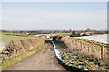
Westfield Drove approaching Hamilton Farm
For a similar view but looking along the other side of the hedge at left, see Image
Image: © Peter Facey
Taken: 8 Feb 2009
0.10 miles
5
Hamilton Farms fields
Looking from the South Downs Way track, near the road, towards Hamilton Farm on a grey afternoon.
Image: © Nigel Freeman
Taken: 29 Jul 2006
0.14 miles