IMAGES TAKEN NEAR TO
Petersfield Road, ALRESFORD, SO24 0DX
Introduction
This page details the photographs taken nearby to Petersfield Road, SO24 0DX by members of the Geograph project.
The Geograph project started in 2005 with the aim of publishing, organising and preserving representative images for every square kilometre of Great Britain, Ireland and the Isle of Man.

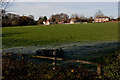
There are currently over 7.5m images from over14,400 individuals and you can help contribute to the project by visiting https://www.geograph.org.uk
Image Map
Images are licensed for reuse under creativecommons.org/licenses/by-sa/2.0
Notes
- Clicking on the map will re-center to the selected point.
- The higher the marker number, the further away the image location is from the centre of the postcode.
Image Listing (40 Images Found)
Images are licensed for reuse under creativecommons.org/licenses/by-sa/2.0
Image
Details
Distance
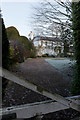
1
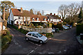
South Street, Ropley
With Hammond Lane where the car has just come down.
[Elevated camera position]
Image: © Peter Facey
Taken: 10 Dec 2011
0.03 miles
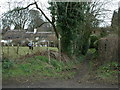
2
South Street, Ropley
South Street continues ahead as a track to a few more houses, with Hammonds Lane heading off to the right as a surfaced road.
Image: © Des Blenkinsopp
Taken: 7 Jul 2023
0.05 miles
3
Hall Place, Ropley
The property has extensive ground beyond, and the house extends backwards into them.
Image: © Peter Facey
Taken: 10 Dec 2011
0.05 miles
4
Snicket at South Street
This path links Petersfield Road with South Street
Image: © Aidan Simons
Taken: 24 Mar 2008
0.08 miles
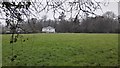
5
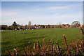
Field between Hammond's Lane and School Lane
Seen from Church Lane. The bungalow in the centre of the picture, to the right of the poplar tree, is in Hammond Lane and is named Lambourne Cottage. The second house from the right edge of the picture is Church Street Farm.
Image: © Peter Facey
Taken: 10 Dec 2011
0.13 miles
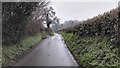
6
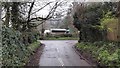
Church Lane junction with Petersfield Road
Image: © James Emmans
Taken: 11 Apr 2016
0.13 miles
7
Field between Vicarage Lane and Hammond's Lane
Seen from Hammnod's Lane. Beyond the field are houses on the south side of Vicarage Lane, left to right: Hardwick House, Dove House, Appin Lodge, Martins.
Image: © Peter Facey
Taken: 10 Dec 2011
0.14 miles
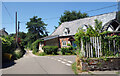
8
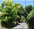
Letter Box in a Leafy Lane
Hammonds Lane, Ropley. A post box is in an old wall outside Laurel Cottage under some very healthy foliage.
Image: © Des Blenkinsopp
Taken: 7 Jul 2023
0.14 miles