IMAGES TAKEN NEAR TO
Bentley Close, WINCHESTER, SO23 7LG
Introduction
This page details the photographs taken nearby to Bentley Close, SO23 7LG by members of the Geograph project.
The Geograph project started in 2005 with the aim of publishing, organising and preserving representative images for every square kilometre of Great Britain, Ireland and the Isle of Man.

There are currently over 7.5m images from over14,400 individuals and you can help contribute to the project by visiting https://www.geograph.org.uk
Image Map (Loading...)


Getting Data...Please wait
Leaflet Map data © OpenStreetMap
Images are licensed for reuse under creativecommons.org/licenses/by-sa/2.0
Notes
- Clicking on the map will re-center to the selected point.
- The higher the marker number, the further away the image location is from the centre of the postcode.
Image Listing (7 Images Found)
Images are licensed for reuse under creativecommons.org/licenses/by-sa/2.0
Image
Details
Distance
1
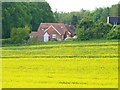
Next to the Rape Seed Field
This house is on the edge of a newish development, but the field next door is still used for growing rape seed plants.
Image: © mike smith
Taken: 25 May 2013
0.11 miles
2
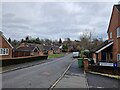
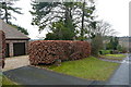
Junction of Glendeep Close with Bentley Close
Image: © Basher Eyre
Taken: 17 Feb 2023
0.12 miles
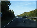
5
End of Nations Hill
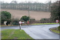
The suburban road, Nations Hill, ends here at its junction with Springvale Road, which marks, for now, the limit of the urban area.
Image: © Graham Horn
Taken: 14 Feb 2010
0.16 miles
6
Nations Hill
A sliver of Nations Hill, a lovely suburban road in the expanding village of King's Worthy, just creeps into the north-east corner of this square.
Image: © Graham Horn
Taken: 14 Feb 2010
0.19 miles
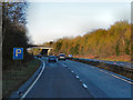
7
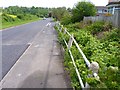
Springvale Road, Kings Worthy
This is a busy link road in the area. Note the concrete post and steel tube barrier. It would appear to date from the mid 20th century, and may even be a little older than that.
Image: © mike smith
Taken: 25 May 2013
0.24 miles