IMAGES TAKEN NEAR TO
Quarry Road, WINCHESTER, SO23 0JF
Introduction
This page details the photographs taken nearby to Quarry Road, SO23 0JF by members of the Geograph project.
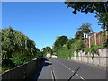
The Geograph project started in 2005 with the aim of publishing, organising and preserving representative images for every square kilometre of Great Britain, Ireland and the Isle of Man.

There are currently over 7.5m images from over14,400 individuals and you can help contribute to the project by visiting https://www.geograph.org.uk
Image Map
Images are licensed for reuse under creativecommons.org/licenses/by-sa/2.0
Notes
- Clicking on the map will re-center to the selected point.
- The higher the marker number, the further away the image location is from the centre of the postcode.
Image Listing (384 Images Found)
Images are licensed for reuse under creativecommons.org/licenses/by-sa/2.0
Image
Details
Distance
1
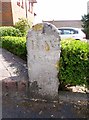
Old Boundary Marker by Quarry Road, Winchester
Boundary Marker by the UC road, in parish of Winchester (Winchester District), Quarry Road, by Chilcomb Heights at back of pavement.
Weathered inscription reads:-
B.W.
18(??)
Surveyed
Milestone Society National ID: HA_WINBW01bm
Image: © Milestone Society
Taken: Unknown
0.01 miles
2
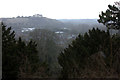
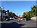
View southwards from The Soke, Winchester
Image: © Robert Eva
Taken: 26 Feb 2018
0.04 miles
3
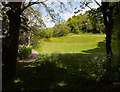
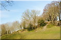
Part of Recreation Ground on St. Giles's Hill
Image: © Peter Facey
Taken: 23 May 2015
0.04 miles
4
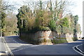
Junction of Quarry Road and Petersfield Road, Winchester
Quarry Road is to the left, Petersfield Road to the right. Photographed from the top of East Hill. Note the magnificent wall, faced with flints.
Image: © Peter Trimming
Taken: 4 Mar 2010
0.04 miles
5
South Downs Way, Winchester to Exton (12)
Mid section of Petersfield Road
Image: © Basher Eyre
Taken: 23 Aug 2014
0.06 miles
6
South Downs Way, Winchester to Exton (11)
All Saints, Winchester
Image: © Basher Eyre
Taken: 23 Aug 2014
0.06 miles
7
Chesil Street car park and old railway line
Looking towards Bar End. This is taken as far as practicable from the same position as John Thorn's 1960 photo Image Winchester Chesil railway station, now a multistorey car park, was behind the photographer. The railway line has become a road. I think John may have taken his photo from the footbridge visible in http://www.gwr.org.uk/notes/dnswinchesterlarge.jpg
Image: © Peter Facey
Taken: 18 Jan 2006
0.06 miles
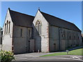
8
All Saints, Chilcomb, Winchester
Victorian Church
Image: © Michael FORD
Taken: Unknown
0.06 miles
9
St.Giles's Hill, Winchester
The top of the hill, and southern viewpoint, photographed from The Soke.
Image: © Peter Trimming
Taken: 4 Mar 2010
0.06 miles
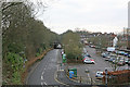
10
South Downs Way, Winchester to Exton (10)
Junction of Petersfield and Canute Roads
Image: © Basher Eyre
Taken: 23 Aug 2014
0.06 miles