IMAGES TAKEN NEAR TO
Andover Road North, WINCHESTER, SO22 6NR
Introduction
This page details the photographs taken nearby to Andover Road North, SO22 6NR by members of the Geograph project.
The Geograph project started in 2005 with the aim of publishing, organising and preserving representative images for every square kilometre of Great Britain, Ireland and the Isle of Man.

There are currently over 7.5m images from over14,400 individuals and you can help contribute to the project by visiting https://www.geograph.org.uk
Image Map
Images are licensed for reuse under creativecommons.org/licenses/by-sa/2.0
Notes
- Clicking on the map will re-center to the selected point.
- The higher the marker number, the further away the image location is from the centre of the postcode.
Image Listing (12 Images Found)
Images are licensed for reuse under creativecommons.org/licenses/by-sa/2.0
Image
Details
Distance
1
The old telephone exchange in Harestock Road
Image: © Basher Eyre
Taken: 30 Jun 2011
0.04 miles
2
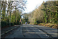
Harestock Road cross roads on Andover Road
Image: © John Firth
Taken: 20 Sep 2013
0.06 miles
3
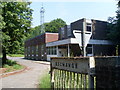
Telephone Exchange, Harestock
Situated in Harestock Road off the B3420 Andover Road North, this TE would appear to date from the early 1970s, being of a design that was introduced around that time. Besides Harestock, this TE also serves Headbourne Worthy, Kings Worthy, Littleton, South Wonston and Weeke nearby. A radio mast with microwave dishes and aerials can be seen behind the TE, whilst a Give Way sign is in the foreground warning BT van drivers to look out for traffic in Harestock Road before coming out. This TE has (01962) 88xxxx numbers whilst its postcode is SO22 6NS.
Image: © David Hillas
Taken: 4 Jul 2011
0.06 miles
4
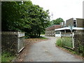
Access road to sewage works off Andover Road North
A tanker is just arriving to discharge its load. The works is well screened by trees from the housing along Andover Road North.
Image: © Peter Facey
Taken: 31 May 2008
0.09 miles
5
Harestock Road
Bounding suburban Winchester, which is to the left.
Image: © Robin Webster
Taken: 13 Jan 2023
0.10 miles
6
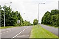
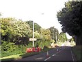
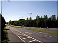
Andover Road North looking towards Winchester
The road here is dual carriageway and it is easy to guess that the left carriageway is of more recent construction.
Image: © Peter Facey
Taken: 31 May 2008
0.11 miles
7
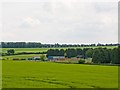
Sewage Works off Andover Road North
Southern Water's wastewater treatment works, site reference number 101718.
Image: © Peter Facey
Taken: 31 May 2008
0.11 miles
8
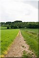
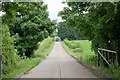
Footpath approaching Andover Road North
Image: © Peter Facey
Taken: 31 May 2008
0.15 miles
9
Andover Road North
Looking south at the dual carriageway section of Andover Road North. This roman road became the A34, but is now the B3420. However it can still be busy road, connecting the present A34 with Winchester city centre. This photo was taken on a Sunday morning! The entrance on the right is to the Army Training Regiment's Sir John Moore Barracks.
Image: © Peter Jordan
Taken: 18 Sep 2005
0.16 miles
10
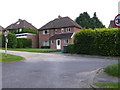
Detached Houses Harestock Close
Harestock close runs parallel and alongside the Andover road, the B3420 running north west out of the city of Winchester. The two roads are on the alignment of an old Roman road. These detached houses face onto open fields.
Image: © Nigel Mykura
Taken: 25 Jul 2012
0.17 miles