IMAGES TAKEN NEAR TO
Pinsent Road, WINCHESTER, SO22 6FR
Introduction
This page details the photographs taken nearby to Pinsent Road, SO22 6FR by members of the Geograph project.
The Geograph project started in 2005 with the aim of publishing, organising and preserving representative images for every square kilometre of Great Britain, Ireland and the Isle of Man.

There are currently over 7.5m images from over14,400 individuals and you can help contribute to the project by visiting https://www.geograph.org.uk
Image Map (Loading...)


Getting Data...Please wait
Leaflet Map data © OpenStreetMap
Images are licensed for reuse under creativecommons.org/licenses/by-sa/2.0
Notes
- Clicking on the map will re-center to the selected point.
- The higher the marker number, the further away the image location is from the centre of the postcode.
Image Listing (8 Images Found)
Images are licensed for reuse under creativecommons.org/licenses/by-sa/2.0
Image
Details
Distance
1
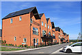
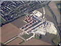
Venta Drive, Winchester
Part of a large new housing estate on a greenfield site on the northern edge of Winchester.
This air photo shows the size of the development. Image
The name comes from Venta Belgarum which is what Winchester was called in Roman times.
By coincidence, a local estate agency is called Belgarum. I wonder if they sold any of these.
Image: © Des Blenkinsopp
Taken: 24 Aug 2018
0.04 miles
2
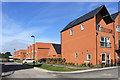
Gardiner Road, Winchester
Part of a large new housing development on the northern edge of Winchester. Air photo of the site on Image
Image: © Des Blenkinsopp
Taken: 24 Aug 2018
0.05 miles
3
Housing development
At Harestock, Littleton. Separated from the existing houses by the B3420, on the line of a Roman Road.
Image: © M J Richardson
Taken: 23 Nov 2017
0.06 miles
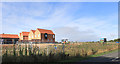
4
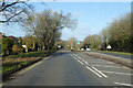
B3420 Andover Road North leaving Winchester
A Roman route.
Image: © Robin Webster
Taken: 13 Jan 2023
0.08 miles
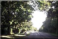
5
South of Well House Lane
Well House Lane is now on the northern edge of suburban Winchester.
Image: © Des Blenkinsopp
Taken: 24 Aug 2018
0.14 miles
6
Start of dual carriageway on Andover Road
Image: © John Firth
Taken: 20 Sep 2013
0.14 miles
7
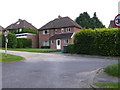
Detached Houses Harestock Close
Harestock close runs parallel and alongside the Andover road, the B3420 running north west out of the city of Winchester. The two roads are on the alignment of an old Roman road. These detached houses face onto open fields.
Image: © Nigel Mykura
Taken: 25 Jul 2012
0.16 miles
8
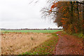
Footpath north of Barton Farm
Running towards the railway line.
Image: © Peter Facey
Taken: 21 Nov 2012
0.19 miles