IMAGES TAKEN NEAR TO
Teg Down Meads, WINCHESTER, SO22 5NF
Introduction
This page details the photographs taken nearby to Teg Down Meads, SO22 5NF by members of the Geograph project.
The Geograph project started in 2005 with the aim of publishing, organising and preserving representative images for every square kilometre of Great Britain, Ireland and the Isle of Man.

There are currently over 7.5m images from over14,400 individuals and you can help contribute to the project by visiting https://www.geograph.org.uk
Image Map
Images are licensed for reuse under creativecommons.org/licenses/by-sa/2.0
Notes
- Clicking on the map will re-center to the selected point.
- The higher the marker number, the further away the image location is from the centre of the postcode.
Image Listing (33 Images Found)
Images are licensed for reuse under creativecommons.org/licenses/by-sa/2.0
Image
Details
Distance
1
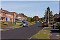
Looking down Teg Down Meads
From outside number 71.
Image: © Peter Facey
Taken: 22 Sep 2012
0.05 miles
2
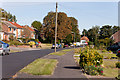
Lower part of Teg down Meads
As it approaches Dean Lane.
Image: © Peter Facey
Taken: 22 Sep 2012
0.05 miles
3
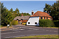
Old Houses at the bottom of Teg Down Meads
Actually on Dean Lane, these houses were there before the housing in Teg down Meads (foreground) were built.
Image: © Peter Facey
Taken: 22 Sep 2012
0.11 miles
4
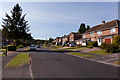
Looking up Teg Down Meads
The first house on the right is number 52.
Image: © Peter Facey
Taken: 22 Sep 2012
0.11 miles
5
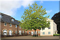
Loyd-Lindsay Square
A new development around a small courtyard.
The only Loyd-Lindsay I can find is the Victorian soldier and philanthropist Robert Loyd-Lindsay, 1st Baron Wantage.
If any local historians can explain the connection I will update the caption.
Image: © Des Blenkinsopp
Taken: 21 Aug 2018
0.13 miles
6
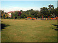
Weeke - playing field, playground and shops
The playing field and playground (refurbished 2 or 3 years ago) are to the west of Stockbridge Road (B3049). In the background are shops with flats above on Stoney Lane.
Image: © Peter Jordan
Taken: 7 Sep 2005
0.15 miles
7

Verge in Hampton Lane
This part of Winchester has easy access to the countryside of Teg Down, high above the city, and just behind us. Individual houses on this private road have verges like these where the spring flowers are showing their glory.
Image: © Graham Horn
Taken: 19 Mar 2011
0.16 miles
8
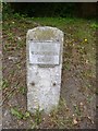
Old Milestone by the B3049, Stockbridge Road, Weeke, Winchester
Metal plate attached to stone post by the B3049, in parish of WINCHESTER (WINCHESTER District), Stockbridge Road, Weeke, opposite Weeke Manor Close on embankment, on South West side of road. Stockbridge flat-top, erected by the Stockbridge & Winchester turnpike trust in the 19th century.
Inscription reads:-
TO
WINCHESTER
1 MILE
Grade II Listed. List Entry Number: 1350725
https://historicengland.org.uk/listing/the-list/list-entry/1350725
Milestone Society National ID: HA_WIST01.
Image: © K Lawrence
Taken: 16 Mar 2003
0.16 miles
9
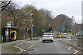
Roundabout on Stockbridge Road, Winchester
The junction with Stoney Lane.
Image: © Robin Webster
Taken: 17 Mar 2018
0.17 miles