IMAGES TAKEN NEAR TO
Walnut Grove, WINCHESTER, SO22 5HR
Introduction
This page details the photographs taken nearby to Walnut Grove, SO22 5HR by members of the Geograph project.
The Geograph project started in 2005 with the aim of publishing, organising and preserving representative images for every square kilometre of Great Britain, Ireland and the Isle of Man.

There are currently over 7.5m images from over14,400 individuals and you can help contribute to the project by visiting https://www.geograph.org.uk
Image Map
Images are licensed for reuse under creativecommons.org/licenses/by-sa/2.0
Notes
- Clicking on the map will re-center to the selected point.
- The higher the marker number, the further away the image location is from the centre of the postcode.
Image Listing (29 Images Found)
Images are licensed for reuse under creativecommons.org/licenses/by-sa/2.0
Image
Details
Distance
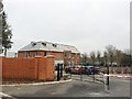
3
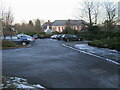
Parking at Westgate Badminton Centre
Parking at Westgate Badminton Centre behind Westgate School
Image: © Shaun Ferguson
Taken: 20 Dec 2009
0.09 miles
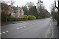
6
Approaching Stockbridge Road roundabout
From Chilbolton Avenue
Image: © John Firth
Taken: 20 Sep 2013
0.12 miles
7
Chilbolton Road at the junction of Stockbridge Road
Image: © David Howard
Taken: 2 Jul 2012
0.12 miles
8
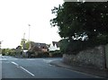
Stockbridge Road at the junction of Cheriton Road
Image: © David Howard
Taken: 3 Jul 2017
0.12 miles
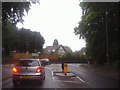
9
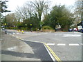
Roundabout on Stockbridge Road
Chilbolton Avenue is on the left.
Image: © Shazz
Taken: 27 Mar 2013
0.12 miles
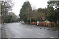
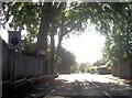
10
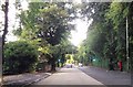
Chilbolton Avenue near Links Road
Light controlled crossing is for adjacent school
Image: © John Firth
Taken: 20 Sep 2013
0.13 miles