IMAGES TAKEN NEAR TO
Middle Road, WINCHESTER, SO22 5EJ
Introduction
This page details the photographs taken nearby to Middle Road, SO22 5EJ by members of the Geograph project.
The Geograph project started in 2005 with the aim of publishing, organising and preserving representative images for every square kilometre of Great Britain, Ireland and the Isle of Man.

There are currently over 7.5m images from over14,400 individuals and you can help contribute to the project by visiting https://www.geograph.org.uk
Image Map
Images are licensed for reuse under creativecommons.org/licenses/by-sa/2.0
Notes
- Clicking on the map will re-center to the selected point.
- The higher the marker number, the further away the image location is from the centre of the postcode.
Image Listing (335 Images Found)
Images are licensed for reuse under creativecommons.org/licenses/by-sa/2.0
Image
Details
Distance
1
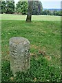
Old Boundary Marker on Clifton Road, Winchester
Parish Boundary Marker on the grass of Oram's Arbour on the east side of Clifton Road, Winchester. On the boundary of St Thomas and Weeke parishes.
Milestone Society National ID: HA_WINSTH06pb
Image: © P Hamilton
Taken: 1 Jun 2023
0.05 miles
3
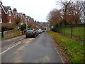
Winchester - Clifton Road
Looking down Clifton Road towards the city centre.
Image: © Chris Talbot
Taken: 14 Dec 2010
0.07 miles
4
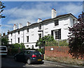
19-22 West End Terrace, Winchester
A short terrace of c1840. Grade II listed.
Image: © Stephen Richards
Taken: 13 Jul 2012
0.08 miles

7
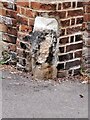
Old Boundary Marker on Oram's Arbour, Winchester
Parish Boundary Marker beside a footpath on Oram's Arbour, set in the brick wall of the former Winchester Union workhouse, now Alison Way, Winchester. On the boundary of St Thomas and Weeke parishes.
Milestone Society National ID: HA_WINSTH07pb
Image: © P Hamilton
Taken: 1 Jun 2023
0.09 miles
8
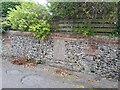
Old Boundary Marker on Step Terrace, Winchester
Parish Boundary Marker set in a brick and stone wall on the southwest side of the junction of Clifton Road and Step Terrace, Winchester. On the boundary of St Thomas and Weeke parishes.
Milestone Society National ID: HA_WINSTH08pb
Image: © P Hamilton
Taken: 1 Jun 2023
0.09 miles
9
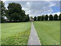
Pathway across Oram's Arbour
Heading towards Clifton Road.
Image: © Mr Ignavy
Taken: 2 Sep 2023
0.09 miles
10

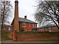
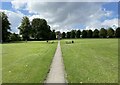
Oram's Arbour, Winchester
The former incinerator chimney of the nearby workhouse (now housing) survives on the left.
Image: © Stephen Richards
Taken: 13 Jul 2012
0.09 miles