IMAGES TAKEN NEAR TO
Parliament Place, WINCHESTER, SO22 4QS
Introduction
This page details the photographs taken nearby to Parliament Place, SO22 4QS by members of the Geograph project.
The Geograph project started in 2005 with the aim of publishing, organising and preserving representative images for every square kilometre of Great Britain, Ireland and the Isle of Man.

There are currently over 7.5m images from over14,400 individuals and you can help contribute to the project by visiting https://www.geograph.org.uk
Image Map
Images are licensed for reuse under creativecommons.org/licenses/by-sa/2.0
Notes
- Clicking on the map will re-center to the selected point.
- The higher the marker number, the further away the image location is from the centre of the postcode.
Image Listing (23 Images Found)
Images are licensed for reuse under creativecommons.org/licenses/by-sa/2.0
Image
Details
Distance
1
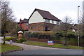
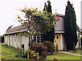
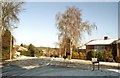
Houses, Parliament Place, Winchester
This development is close to Oliver Cromwell's Battery, so the road name derives from the Parliamentarians he led.
Image: © Robin Webster
Taken: 17 Mar 2018
0.04 miles
2
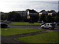
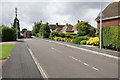
Roundabout on Badger Farm Road
This small roundabout on Badger Farm Road (A3090) is quite busy. It provides access to the large Badger Farm estate, a Sainsbury's store and the houses in the photo at Parliament Place.
Image: © Peter Jordan
Taken: 16 Oct 2005
0.05 miles
3
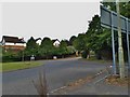
Roundabout on Badger Farm Road, Olivers Battery
Image: © David Howard
Taken: 16 Jun 2018
0.07 miles
4
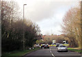
Sainsbury roundabout from Badger Farm Lane
The A3090
Image: © John Firth
Taken: 15 Apr 2013
0.07 miles
6
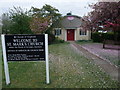
Church of St Mark, Oliver's Battery, Winchester
Image: © Tim Heaton
Taken: 10 May 2010
0.11 miles
7
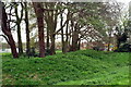
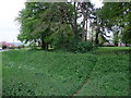
Earthworks, Oliver's Battery
Though long known as Oliver Cromwell's Battery, the earthworks here are actually probably Roman, on an Iron Age site. The shops Image and church Imagecan be seen through the trees.
Image: © Pierre Terre
Taken: 26 Apr 2006
0.11 miles
8
Oliver's Battery earthworks, Winchester
Probably an Iron Age earthwork. Local custom holds that the site was used by Oliver Cromwell's cannon during the siege of 1645.
Image: © Tim Heaton
Taken: 10 May 2010
0.12 miles
9
Austen Avenue, Oliver's Battery
Junction of Austen Avenue and Keats Close, with melting snow.
Image: © Pierre Terre
Taken: 9 Jan 2004
0.13 miles
10
Compton Way
This suburban street in Oliver's Battery is also part of the route of the Clarendon Way footpath from Winchester to Salisbury. It has views across the Itchen Valley to St Catherine's Hill.
Image: © Pierre Terre
Taken: 19 Aug 2008
0.13 miles