IMAGES TAKEN NEAR TO
Olivers Battery Road North, WINCHESTER, SO22 4JA
Introduction
This page details the photographs taken nearby to Olivers Battery Road North, SO22 4JA by members of the Geograph project.
The Geograph project started in 2005 with the aim of publishing, organising and preserving representative images for every square kilometre of Great Britain, Ireland and the Isle of Man.

There are currently over 7.5m images from over14,400 individuals and you can help contribute to the project by visiting https://www.geograph.org.uk
Image Map
Images are licensed for reuse under creativecommons.org/licenses/by-sa/2.0
Notes
- Clicking on the map will re-center to the selected point.
- The higher the marker number, the further away the image location is from the centre of the postcode.
Image Listing (38 Images Found)
Images are licensed for reuse under creativecommons.org/licenses/by-sa/2.0
Image
Details
Distance
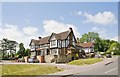
1
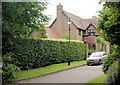
Westminster Gate
Infill housing off Oliver's Battery Road North.
Image: © Pierre Terre
Taken: 19 Aug 2008
0.04 miles
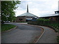
2
Olivers Battery, St. Stephen's Catholic Church
On Olivers Battery Road North: http://www.hampshiredowns.org.uk/StStephenWinchester.aspx
Image: © Mike Faherty
Taken: 4 Aug 2013
0.07 miles
3
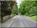
Olivers Battery Road North, Winchester
This road has been adopted by the Clarendon Way, whose destination is Winchester City Centre. The route however takes a long sweep to the south before following the River Itchen towards the cathedral - an exercise that adds around 2 or 3 miles onto the length of the trail. This accounts for our presence on Olivers Battery Road.
Image: © Chris Heaton
Taken: 10 May 2010
0.08 miles
4
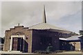
St. Stephen Roman Catholic Church, Stanmore
Image: © Michael FORD
Taken: Unknown
0.08 miles
5
Church of St Stephen, Winchester
Viewed from the Clarendon Way on Oliver's Battery Road North
Image: © Tim Heaton
Taken: 10 May 2010
0.09 miles
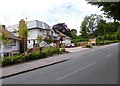
6
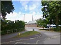
The Stanmore pub, Stanmore Lane
The whole lane is on a hillside and this pub is near the top end. Since photographing, it has been demolished and replaced by a nursing home, see http://www.geograph.org.uk/photo/2272887 and http://www.geograph.org.uk/photo/2272883 .
Image: © Peter Facey
Taken: 29 Jun 2008
0.10 miles
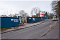
7
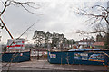
Dementia Care Home under construction, Stanmore Lane
A 56-bed purpose built dementia care home under construction for http://www.coltencare.co.uk/ at the western end of Stanmore Lane, upon the site of the demolished Image
Image: © Peter Facey
Taken: 17 Feb 2011
0.11 miles
8
Stanmore, residential home
St Catherines View Nursing & Residential Home, on Stanmore Lane: http://stcatherinesview.coltencare.co.uk/st-catherines-view
Image: © Mike Faherty
Taken: 4 Aug 2013
0.11 miles
9
Dementia Care Home under construction, Stanmore Lane
A 56-bed purpose built dementia care home under construction for http://www.coltencare.co.uk/ at the western end of Stanmore Lane, upon the site of the demolished Image
Image: © Peter Facey
Taken: 17 Feb 2011
0.12 miles
10
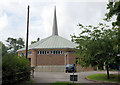
St Stephen's Church, Oliver's Battery
A modern Roman Catholic church in Oliver's Battery Road North.
Image: © Pierre Terre
Taken: 19 Aug 2008
0.12 miles