IMAGES TAKEN NEAR TO
The Valley, WINCHESTER, SO22 4FS
Introduction
This page details the photographs taken nearby to The Valley, SO22 4FS by members of the Geograph project.
The Geograph project started in 2005 with the aim of publishing, organising and preserving representative images for every square kilometre of Great Britain, Ireland and the Isle of Man.

There are currently over 7.5m images from over14,400 individuals and you can help contribute to the project by visiting https://www.geograph.org.uk
Image Map
Images are licensed for reuse under creativecommons.org/licenses/by-sa/2.0
Notes
- Clicking on the map will re-center to the selected point.
- The higher the marker number, the further away the image location is from the centre of the postcode.
Image Listing (64 Images Found)
Images are licensed for reuse under creativecommons.org/licenses/by-sa/2.0
Image
Details
Distance
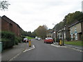
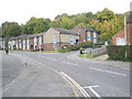
2
Houses in The Valley, Stanmore, Winchester
The corner of Octavia Hill is on the right.
Image: © Jaggery
Taken: 28 Sep 2014
0.04 miles
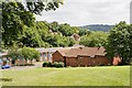
3

St Luke's Church, Stanmore
As it is on the side of quite a steep hill, and has other buildings close by, it is hard to get a good view of this church.
Image: © Peter Facey
Taken: 29 Jun 2008
0.04 miles
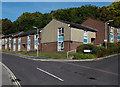
4
Lent Hill Court, Stanmore, Winchester
Flats on the south side of The Valley, viewed from the corner of Octavia Hill.
Image: © Jaggery
Taken: 28 Sep 2014
0.05 miles
5
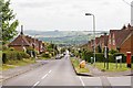
Looking down the full length of Battery Hill, Stanmore
At the vanishing point, St Luke's church can be seen. The road in right foreground is Drayton Street.
Image: © Peter Facey
Taken: 29 Jun 2008
0.05 miles
6

East window of St Luke's Church, Stanmore
Image: © Peter Facey
Taken: 29 Jun 2008
0.05 miles
7

St Luke's Church, Stanmore
At the bottom of the long, straight, Battery Hill which becomes Mildmay Street when it turns right here.
Image: © Peter Facey
Taken: 29 Jun 2008
0.05 miles
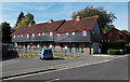
8
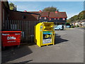
Yellow donations bin, Stanmore, Winchester
Located outside the Sportsmans Club, http://www.geograph.org.uk/photo/4186201, the Hampshire and Isle of Wight Air Ambulance bin is for donations of shoes, clothing and textiles.
Image: © Jaggery
Taken: 28 Sep 2014
0.06 miles
9
Looking across The Valley at Octavia Hill, Winchester
The Valley is the street running left to right in middle ground. The pointy-roofed buildings beyond are probably in Octavia Hill.
Image: © Peter Facey
Taken: 29 Jun 2008
0.06 miles
10
Approaching the junction of The Valley and Octavia Hill
Image: © Basher Eyre
Taken: 17 Oct 2009
0.06 miles