IMAGES TAKEN NEAR TO
Wayneflete Place, WINCHESTER, SO22 4DB
Introduction
This page details the photographs taken nearby to Wayneflete Place, SO22 4DB by members of the Geograph project.
The Geograph project started in 2005 with the aim of publishing, organising and preserving representative images for every square kilometre of Great Britain, Ireland and the Isle of Man.

There are currently over 7.5m images from over14,400 individuals and you can help contribute to the project by visiting https://www.geograph.org.uk
Image Map
Images are licensed for reuse under creativecommons.org/licenses/by-sa/2.0
Notes
- Clicking on the map will re-center to the selected point.
- The higher the marker number, the further away the image location is from the centre of the postcode.
Image Listing (25 Images Found)
Images are licensed for reuse under creativecommons.org/licenses/by-sa/2.0
Image
Details
Distance
1
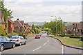
Looking down Stanmore Lane, Winchester
Road in right foreground is Minden Way.
Image: © Peter Facey
Taken: 29 Jun 2008
0.09 miles
2

Vanishing telephone box at Wykeham Place, Winchester
A notice within said that due to lack of use it was intended to remove this box. There was no glass in the top half of the door.
Image: © Peter Facey
Taken: 29 Jun 2008
0.10 miles
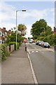
3
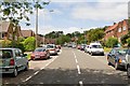
Looking up Stanmore Lane, Winchester
This is the higher, western, part of the lane.
Image: © Peter Facey
Taken: 29 Jun 2008
0.10 miles
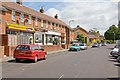
4

Stanmore Library and Gecko Hair, Wavell Way
On the corner of Wavell Way and Stanmore Lane. The library is run by Hampshire County Council.
Image: © Peter Facey
Taken: 29 Jun 2008
0.11 miles
5
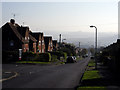
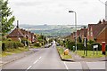
Battery Hill, Stanmore, Winchester
On a bright autumn morning, looking eastwards down Battery Hill on the Stanmore estate. Twyford Down is in the misty distance.
Image: © Peter Jordan
Taken: 16 Oct 2005
0.13 miles
7

St Luke's Church, Stanmore
At the bottom of the long, straight, Battery Hill which becomes Mildmay Street when it turns right here.
Image: © Peter Facey
Taken: 29 Jun 2008
0.16 miles
8
Looking down the full length of Battery Hill, Stanmore
At the vanishing point, St Luke's church can be seen. The road in right foreground is Drayton Street.
Image: © Peter Facey
Taken: 29 Jun 2008
0.16 miles
9
Looking up Stanmore Lane, Winchester
From near Cromwell Road.
Image: © Peter Facey
Taken: 29 Jun 2008
0.16 miles
10
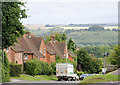
Stanmore Lane, Winchester
The view from near the top of the hill by the Stanmore Hotel. In the distance is St Catherine's Hill on the far side of the Itchen.
Image: © Pierre Terre
Taken: 19 Aug 2008
0.17 miles