IMAGES TAKEN NEAR TO
Princes Place, WINCHESTER, SO22 4AR
Introduction
This page details the photographs taken nearby to Princes Place, SO22 4AR by members of the Geograph project.
The Geograph project started in 2005 with the aim of publishing, organising and preserving representative images for every square kilometre of Great Britain, Ireland and the Isle of Man.

There are currently over 7.5m images from over14,400 individuals and you can help contribute to the project by visiting https://www.geograph.org.uk
Image Map
Images are licensed for reuse under creativecommons.org/licenses/by-sa/2.0
Notes
- Clicking on the map will re-center to the selected point.
- The higher the marker number, the further away the image location is from the centre of the postcode.
Image Listing (95 Images Found)
Images are licensed for reuse under creativecommons.org/licenses/by-sa/2.0
Image
Details
Distance
1
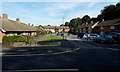
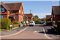
Drummond Close Winchester
On the north side of Stanmore Lane.
Image: © Jaggery
Taken: 28 Sep 2014
0.03 miles
2
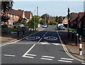
Kings Avenue, Stanmore, Winchester
Viewed from Stanmore Lane. A 20mph speed limit is in force near Stanmore Primary School.
Image: © Jaggery
Taken: 28 Sep 2014
0.05 miles
4
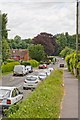
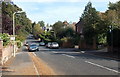
Stanmore Lane, Winchester
The lower, eastern, end of the lane, still going down hill. The pavement here is at a higher level than the road. Green Jacket Close is first left beyond the grey van.
Image: © Peter Facey
Taken: 29 Jun 2008
0.08 miles
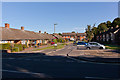
5
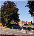
South end of Kings Avenue
Looking across Stanmore Lane.
Image: © Peter Facey
Taken: 22 Sep 2012
0.08 miles
6
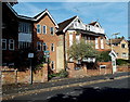
Wykeham House flats, Winchester
Viewed across Christchurch Road near the Barnes Close junction.
The nameplate on the wall shows WYKEHAM HOUSE FLATS 4 5 6.
Image: © Jaggery
Taken: 28 Sep 2014
0.08 miles
7
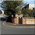
Barnes Close Gas Installation, Winchester
On the corner of Barnes Close and Christchurch Road, a padlocked brown door leads to a Southern Gas Networks gas installation. A notice shows a phone number to call before beginning any work on or within 10 metres of this site, or in an emergency.
Image: © Jaggery
Taken: 28 Sep 2014
0.09 miles
8
Barnes Close, Winchester
In late September 2014, Barnes Close is a through road from Christchurch Road behind the camera to
St Cross Road ahead. Presumably it was named at a time when one of these road junctions did not exist.
Image: © Jaggery
Taken: 28 Sep 2014
0.09 miles
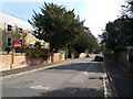
9
Christchurch Road, Winchester
Looking NNE from the Lower Stanmore Lane end.
Image: © Jaggery
Taken: 28 Sep 2014
0.09 miles
10
Green Jacket Close, Stanmore
I think this may contain housing for retired members of the Green Jacket Regiment.
Image: © Peter Facey
Taken: 22 Sep 2012
0.10 miles