IMAGES TAKEN NEAR TO
Sutton Scotney, WINCHESTER, SO21 3LD
Introduction
This page details the photographs taken nearby to SO21 3LD by members of the Geograph project.
The Geograph project started in 2005 with the aim of publishing, organising and preserving representative images for every square kilometre of Great Britain, Ireland and the Isle of Man.

There are currently over 7.5m images from over14,400 individuals and you can help contribute to the project by visiting https://www.geograph.org.uk
Image Map
Images are licensed for reuse under creativecommons.org/licenses/by-sa/2.0
Notes
- Clicking on the map will re-center to the selected point.
- The higher the marker number, the further away the image location is from the centre of the postcode.
Image Listing (11 Images Found)
Images are licensed for reuse under creativecommons.org/licenses/by-sa/2.0
Image
Details
Distance
1
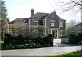
Egypt
Egypt is a small settlement of a few houses (one row) in the parish of Wonston, A clue to the origin of the name may be seen on the street sign; Alexandria Rd".
Image: © Kelvin Davies
Taken: 12 Jun 2005
0.03 miles
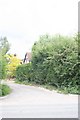
2
House at Egypt
The hamlet to the northeast of Sutton Scotney is called Egypt, and there is also an Alexandria Road. This house is on the former A30, now considerably quieter than in the 1970s.
Image: © Graham Horn
Taken: 7 Apr 2011
0.06 miles
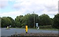
3

Roundabout ahead, Sutton Scotney
Looking from the former route of the A30, now an unclassified road, to the roundabout where the rerouted A30 comes in from the right.
Image: © Robin Webster
Taken: 16 Dec 2017
0.14 miles
5

Petrol filling station at Sutton Scotney
This is at the junction of the former A34 and the former A30. Both now take different routes and the petrol station probably does much less trade, although I would not be surprised if the traffic on these roads is approaching the amount when they were bypassed. All quiet today though.
Image: © Graham Horn
Taken: 7 Apr 2011
0.16 miles
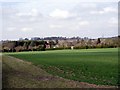
6
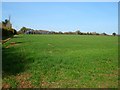
Farmland, Wonston
A bridleway follows the left edge of this field.
Image: © Andrew Smith
Taken: 11 Mar 2012
0.17 miles
7
Field to the east of Egypt
Looking west from the old A30/Norton Manor crossroads. The houses are in SU4640 and are part of Egypt - a village adjoining Sutton Scotney.
Image: © Peter Jordan
Taken: 16 Apr 2006
0.17 miles
8
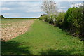
Farmland at Egypt
A public footpath runs along the western edge of this field, with the houses of Alexandria Road behind. This view is east, along the inside of the hedge line of the former A30.
Image: © Graham Horn
Taken: 7 Apr 2011
0.18 miles
9
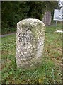
Old Milestone by the A30, Stockbridge Road East, Sutton Scotney
Carved stone post by the A30, in parish of WONSTON (WINCHESTER District), Sutton Scotney, on the verge, on South side of road. Hartford limestone diamond, erected by the Stockbridge & Basingstoke turnpike trust in the 18th century.
Inscription reads:-
: ST(OCK) / BRI(DGE) / (8) : : (BA)SING / (ST)OKE / 13 :
Winchester HER listed.
HER No.: MWC158 https://www.heritagegateway.org.uk/Gateway/Results_Single.aspx?uid=MWC158&resourceID=1013
Milestone Society National ID: HA_BAST13.
Image: © K Lawrence
Taken: 24 Oct 2002
0.19 miles
10
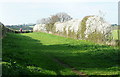
Bridleway at Egypt
This is a lovely wide bridleway, edged with blackthorn coming into bloom. The lady's dog bounded up to me for a sniff. It had been in the river.
Image: © Graham Horn
Taken: 7 Apr 2011
0.23 miles