IMAGES TAKEN NEAR TO
Downs Road, WINCHESTER, SO21 3EU
Introduction
This page details the photographs taken nearby to Downs Road, SO21 3EU by members of the Geograph project.
The Geograph project started in 2005 with the aim of publishing, organising and preserving representative images for every square kilometre of Great Britain, Ireland and the Isle of Man.

There are currently over 7.5m images from over14,400 individuals and you can help contribute to the project by visiting https://www.geograph.org.uk
Image Map (Loading...)


Getting Data...Please wait
Leaflet Map data © OpenStreetMap
Images are licensed for reuse under creativecommons.org/licenses/by-sa/2.0
Notes
- Clicking on the map will re-center to the selected point.
- The higher the marker number, the further away the image location is from the centre of the postcode.
Image Listing (47 Images Found)
Images are licensed for reuse under creativecommons.org/licenses/by-sa/2.0
Image
Details
Distance
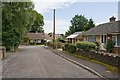
1
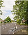
Looking along Downs Road at Orchard Road
Orchard Road is that in right foreground.
Image: © Peter Facey
Taken: 21 Aug 2008
0.04 miles
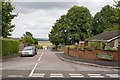
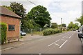
2

Entering South Wonston on Downs Road
Downs Road is the principal road through the village. The nearby Worthy Down army camp results in plenty of people running around keeping fit.
Image: © Peter Facey
Taken: 21 Aug 2008
0.07 miles
4
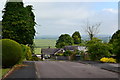
Markson Road, South Wonston
With view of distant fields beyond.
Image: © David Martin
Taken: 30 Jun 2013
0.08 miles
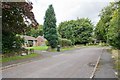
5
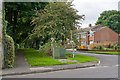
Groves Close and footpath
Looking across Downs Road. The footpath is a continuation of Stainers Lane, and runs to Lower Road. It was doubtless there long before the Close.
Image: © Peter Facey
Taken: 20 Aug 2008
0.10 miles
6
Part of Orchard Close, South Wonston
The close is L-shaped.
Image: © Peter Facey
Taken: 21 Aug 2008
0.10 miles
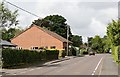
7
Site of former Tin Tabernacle in Downs Road
The building on the left is the village hall. Beyond it, screened off, is the place where there was a corrugated iron church built in 1909, used till 1996, and dismantled in 2006. The church is still shown on Google Earth and OS maps. It lives on at the Weald & Downland Open Air Museum, see http://www.wealddown.co.uk/News/news-release-south-wonston-church.htm
For more on the history of this church see http://www.southwonston-church.co.uk/History%20of%20church.html
It appears that the rector paid £8 out of his own pocket for this plot of land in 1909. It's asking price in 2008 was around £150,000 which explains why it has not so far been possible to use it as a car park for the adjacent village hall.
Image: © Peter Facey
Taken: 20 Aug 2008
0.11 miles
8
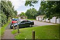
Garages and car park off Groves Close and Downlands Way
The park is convenient for the nearby nursery school, for which see http://www.swons.co.uk/
The path in the foreground allows pedestrians to walk from the closed end of Orchard Road to Groves Close (which is not a close but a road that runs into Downlands Way).
Image: © Peter Facey
Taken: 21 Aug 2008
0.11 miles
9
Part of Orchard Close, South Wonston
The close is L-shaped.
Image: © Peter Facey
Taken: 21 Aug 2008
0.12 miles
10
Village Hall, Downs Road
South Wonston Village Hall.
Image: © Peter Facey
Taken: 20 Aug 2008
0.13 miles