IMAGES TAKEN NEAR TO
Lovell Close, WINCHESTER, SO21 3EN
Introduction
This page details the photographs taken nearby to Lovell Close, SO21 3EN by members of the Geograph project.
The Geograph project started in 2005 with the aim of publishing, organising and preserving representative images for every square kilometre of Great Britain, Ireland and the Isle of Man.

There are currently over 7.5m images from over14,400 individuals and you can help contribute to the project by visiting https://www.geograph.org.uk
Image Map
Images are licensed for reuse under creativecommons.org/licenses/by-sa/2.0
Notes
- Clicking on the map will re-center to the selected point.
- The higher the marker number, the further away the image location is from the centre of the postcode.
Image Listing (45 Images Found)
Images are licensed for reuse under creativecommons.org/licenses/by-sa/2.0
Image
Details
Distance
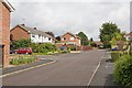
1
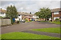
Lovell Close
At the western end of Anders Road (seen here at right). The Close continues at left behind camera.
Image: © Peter Facey
Taken: 20 Aug 2008
0.03 miles
2
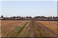
Footpath approaching South Wonston
The customary line of the footpath seems to be a tad to the east of that shown on the map.
Image: © Peter Facey
Taken: 23 Nov 2012
0.03 miles
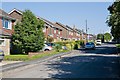
3
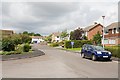
Housing in Anders Road
First left is Armstrong Close.
Image: © Peter Facey
Taken: 20 Aug 2008
0.03 miles
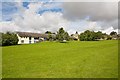
4
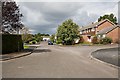
Anders Road
There is housing along both sides of Anders Road. Left foreground is a hammerhead turning point at this closed end. First right is Hunt Close.
Image: © Peter Facey
Taken: 20 Aug 2008
0.06 miles
5
Borman Way
Affording access to housing in Anders Road and the Closes off it. (The name not to be confused with Martin Bormann.)
Image: © Peter Facey
Taken: 20 Aug 2008
0.07 miles
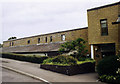
8
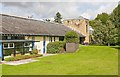
South Wonston Primary School and St Margaret's Church
South Wonston Primary School (http://www.southwonston.hants.sch.uk/ ) and St Margaret's Church (http://www.southwonston-church.co.uk/index.html ) share the site. The church (right), which was built in 1996, is joined to the school buildings (left).
This view is looking across the school's playing field which is not open to the public. Access for this photograph by kind permission of St Margaret's.
Image: © Peter Facey
Taken: 24 Aug 2008
0.10 miles
9
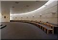
Interior of St Margaret's Church, South Wonston
The principal room is semicircular. See also Image
Image: © Peter Facey
Taken: 24 Aug 2008
0.10 miles
10
St Margaret's Church, Downs Road, South Wonston
South Wonston Primary School (http://southwonston.hants.sch.uk/ ) and St Margaret's Church (http://www.southwonston-church.co.uk/index.html ) share the site and the church (right), which was built in 1996, is joined to the school buildings (left). The church occupies a narrow site within the row of residential houses along Downs Road. The church was partly sunken to meet objections about its height from neighbours. The tower-like structure sadly lacks a spire or other feature to top it off. The rectangular hole in the masonry at the top left of the tower, which I first thought might contain a bell, in fact contains a TV aerial.
This southeastern side of the church is only visible from the grounds of the school which are not open to the public. Access for this photograph by kind permission of St Margaret's.
Image: © Peter Facey
Taken: 24 Aug 2008
0.10 miles