IMAGES TAKEN NEAR TO
Farley Mount Road, WINCHESTER, SO21 2JE
Introduction
This page details the photographs taken nearby to Farley Mount Road, SO21 2JE by members of the Geograph project.
The Geograph project started in 2005 with the aim of publishing, organising and preserving representative images for every square kilometre of Great Britain, Ireland and the Isle of Man.

There are currently over 7.5m images from over14,400 individuals and you can help contribute to the project by visiting https://www.geograph.org.uk
Image Map
Images are licensed for reuse under creativecommons.org/licenses/by-sa/2.0
Notes
- Clicking on the map will re-center to the selected point.
- The higher the marker number, the further away the image location is from the centre of the postcode.
Image Listing (2 Images Found)
Images are licensed for reuse under creativecommons.org/licenses/by-sa/2.0
Image
Details
Distance
1
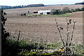
Pittdown Farm
These buildings on Pittdown are probably part of the larger South Lynch estate. Although there are arable fields in the foreground, it looks as though there are pig sties behind the buildings. The geology is chalk, and the soil is thin with the chalk and flint visible.
Image: © Graham Horn
Taken: 19 Mar 2011
0.07 miles
2
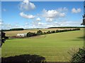
Pitt Down looking W from Enmill Lane
Woodland on horizon at right is Pittdown Plantation. Farm building in foreground unknown.
Image: © Peter Facey
Taken: 25 Aug 2005
0.08 miles