IMAGES TAKEN NEAR TO
Brickmakers Road, WINCHESTER, SO21 1TT
Introduction
This page details the photographs taken nearby to Brickmakers Road, SO21 1TT by members of the Geograph project.
The Geograph project started in 2005 with the aim of publishing, organising and preserving representative images for every square kilometre of Great Britain, Ireland and the Isle of Man.

There are currently over 7.5m images from over14,400 individuals and you can help contribute to the project by visiting https://www.geograph.org.uk
Image Map
Images are licensed for reuse under creativecommons.org/licenses/by-sa/2.0
Notes
- Clicking on the map will re-center to the selected point.
- The higher the marker number, the further away the image location is from the centre of the postcode.
Image Listing (25 Images Found)
Images are licensed for reuse under creativecommons.org/licenses/by-sa/2.0
Image
Details
Distance
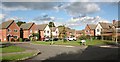
1
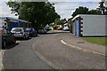
Callowing Close, Colden Common
One of the Closes off Brickmakers Road which provide nothing but garaging for housing in the adjacent Greens.
Image: © Peter Facey
Taken: 11 Jun 2006
0.05 miles
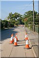
2
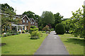
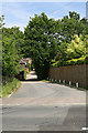
Piping Green, Colden Common
There are a number of Greens around Brickmakers Road. They are accessible only on foot via the kind of path shown, and have well landscaped open-plan front gardens. There are a number of Closes off Brickmakers Road that contain only garaging for these houses.
Image: © Peter Facey
Taken: 11 Jun 2006
0.06 miles
3
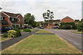
Tees Farm Road, Colden Common
Turning at right to Oak Tree Close. Pennington Close off picture left.
Image: © Peter Facey
Taken: 11 Jun 2006
0.13 miles
4
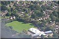
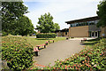
Winchester District : Colden Common Primary School
Looking down towards the primary school and grounds which serve Colden Common.
Image: © Lewis Clarke
Taken: 28 Aug 2012
0.13 miles
5
Drainage Works in Church Lane, Colden Common
An unusually quiet view of Church Lane which has been closed to traffic to permit laying of a larger diameter drainage pipe. The tarmac in the foreground has been cut along the line of the pipe in preparation for digging out.
Image: © Peter Facey
Taken: 26 Sep 2008
0.14 miles
6
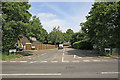
Junction of Brickmakers Road with Church Lane, Colden Common
Bricks were made from local clay in the past. Brickmakers Road today provides access to a large residential area but with plenty of greenery. The small road running off Brickmakers and parallel to Church Lane provides access to houses that are part of Church Lane.
Image: © Peter Facey
Taken: 11 Jun 2006
0.15 miles
7
Ash Close, Colden Common
Looking NE from St Vigor Way
Image: © Peter Facey
Taken: 1 Nov 2005
0.18 miles
8
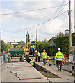
Brambridge Flood Protection Scheme
Enlarging the drains in Church Lane, Colden Common. An underground storage tank holding nearly 1 million litres of water is to be built 1Km behind photographer, together with equipment to pump its contents to Eastleigh Chickenhall Wastewater Treatment Works. The tank will take surface water flowing into drains in Church Lane and Spring Lane, Colden Common, and hold it until a storm has passed. The drainage pipes below those roads, which have long been inadequate, are being upgraded by the laying of bigger plastic pipes on top of the old pipes. The work is being carried out by contractor 4Delivery on behalf of Southern Water.
Image: © Peter Facey
Taken: 9 Oct 2008
0.18 miles
9
Primary School, Upper Moors Road, Colden Common
Image: © Peter Facey
Taken: 11 Jun 2006
0.18 miles
10
Vears Lane seen from Church Lane, Colden Common
This lane is one of the older parts of Colden Common. Today it is surrounded by later housing developments and cut in two by St Vigor Way.
Image: © Peter Facey
Taken: 11 Jun 2006
0.19 miles