IMAGES TAKEN NEAR TO
Hilly Close, WINCHESTER, SO21 1LW
Introduction
This page details the photographs taken nearby to Hilly Close, SO21 1LW by members of the Geograph project.
The Geograph project started in 2005 with the aim of publishing, organising and preserving representative images for every square kilometre of Great Britain, Ireland and the Isle of Man.

There are currently over 7.5m images from over14,400 individuals and you can help contribute to the project by visiting https://www.geograph.org.uk
Image Map
Images are licensed for reuse under creativecommons.org/licenses/by-sa/2.0
Notes
- Clicking on the map will re-center to the selected point.
- The higher the marker number, the further away the image location is from the centre of the postcode.
Image Listing (87 Images Found)
Images are licensed for reuse under creativecommons.org/licenses/by-sa/2.0
Image
Details
Distance
1
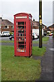
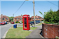
Former telephone kiosk in Beech Grove
Now a book exchange.
Image: © David Martin
Taken: 26 Dec 2021
0.06 miles
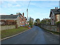
3
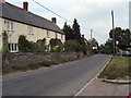
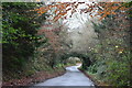
Eastern end of Owslebury Main Road
Looking E. Properties off picture to right are Gorse Down. The village of Owslebury is clustered around a single long street.
Image: © Peter Facey
Taken: 22 Sep 2005
0.07 miles
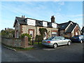
7
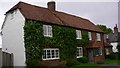
(Not so) Main Road, Owslebury: looking north-east
Image: © Basher Eyre
Taken: 2 Jan 2011
0.13 miles