IMAGES TAKEN NEAR TO
School Lane, WINCHESTER, SO21 1BE
Introduction
This page details the photographs taken nearby to School Lane, SO21 1BE by members of the Geograph project.
The Geograph project started in 2005 with the aim of publishing, organising and preserving representative images for every square kilometre of Great Britain, Ireland and the Isle of Man.

There are currently over 7.5m images from over14,400 individuals and you can help contribute to the project by visiting https://www.geograph.org.uk
Image Map
Images are licensed for reuse under creativecommons.org/licenses/by-sa/2.0
Notes
- Clicking on the map will re-center to the selected point.
- The higher the marker number, the further away the image location is from the centre of the postcode.
Image Listing (194 Images Found)
Images are licensed for reuse under creativecommons.org/licenses/by-sa/2.0
Image
Details
Distance
1
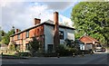
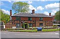
Junction Northington Road and School Lane
The houses on this small development are quite new, but are built in traditional style to blend in with older parts of the village.
Image: © mike smith
Taken: 25 May 2013
0.02 miles
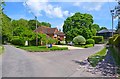
2
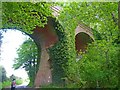
Railway viaduct at Itchen Abbas
The viaduct is still here but no trains have used it since the line closed in 1973. It had opened from Alton to Winchester in 1865 as the Mid Hants Railway. Today the section from Alton to Alresford (east of here) is run as the Watercress Line preserved steam railway.
Image: © Graham Horn
Taken: 23 Mar 2011
0.05 miles
3
Railway viaduct at Itchen Abbas
This viaduct used to carry the former Mid-Hants railway over Northington Road. See a summer view at Image
Image: © Peter Jordan
Taken: 21 Jan 2006
0.05 miles
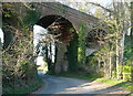
4
Railway Viaduct
This massive viaduct is over Northington Road in Itchen Abbas. It used to carry the railway that connected Alton to Winchester, which opened in 1865 and closed in 1973.
Image: © mike smith
Taken: 25 May 2013
0.06 miles
5
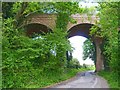
Railway Viaduct
This massive viaduct is over Northington Road in Itchen Abbas. It used to carry the railway that connected Alton to Winchester, which opened in 1865 and closed in 1973.
Image: © mike smith
Taken: 25 May 2013
0.06 miles
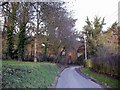
6
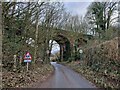
Former railway bridge in Northington Road
This would have been on the Mid-Hants Railway as the train approached Itchen Abbas Railway Station from Alresford https://en.wikipedia.org/wiki/Mid-Hants_Railway#/media/File:Mid-hants-rly.png This part, unlike the line from Alresford to Alton, has not been preserved.
Image: © Basher Eyre
Taken: 16 Feb 2023
0.06 miles
7
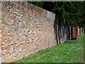
Wall, Avington
Early 18th century boundary wall to Avington House with a K6 type telephone box standing against it.
Image: © Maigheach-gheal
Taken: 30 May 2009
0.07 miles
8
The Old House, Itchen Abbas
Simply named "The Old House", the building is of timber frame and brick construction.
It dates from the 17th century and is Grade II listed.
Image: © mike smith
Taken: 25 May 2013
0.07 miles
9
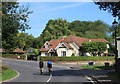
Cyclists at Itchen Abbas
Approaching Station Hill. The station is long gone, but would have been on the continuation of the line that now stops at Alresford.
Image: © Des Blenkinsopp
Taken: 24 Aug 2018
0.07 miles