IMAGES TAKEN NEAR TO
Brock Mews, STOCKBRIDGE, SO20 8RB
Introduction
This page details the photographs taken nearby to Brock Mews, SO20 8RB by members of the Geograph project.
The Geograph project started in 2005 with the aim of publishing, organising and preserving representative images for every square kilometre of Great Britain, Ireland and the Isle of Man.

There are currently over 7.5m images from over14,400 individuals and you can help contribute to the project by visiting https://www.geograph.org.uk
Image Map
Images are licensed for reuse under creativecommons.org/licenses/by-sa/2.0
Notes
- Clicking on the map will re-center to the selected point.
- The higher the marker number, the further away the image location is from the centre of the postcode.
Image Listing (12 Images Found)
Images are licensed for reuse under creativecommons.org/licenses/by-sa/2.0
Image
Details
Distance
1
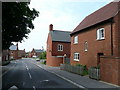
The Avenue, Kentsboro
New housing on the edge of this military village.
Image: © Jonathan Billinger
Taken: 22 May 2008
0.04 miles
2
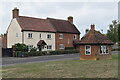
Houses and shelter on The Green at Kentsboro
The shelter seems a nice touch on this green with a play area, but has unfortunately lost most of its glass.
Image: © David Martin
Taken: 3 Sep 2022
0.10 miles
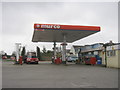
7
Petrol station on Salisbury Road, Kentsboro
Image: © David Howard
Taken: 20 Jun 2020
0.16 miles
8
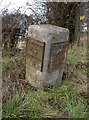
Old Milestone by the A343, Kentsboro
Carved stone post by the A343, in parish of OVER WALLOP (TEST VALLEY District), Kentsboro, by the road, on West side of road. Lopcombe pillar, erected by the Andover & Basingstoke turnpike trust in the 19th century.
Inscription reads:-
: LONDON / 69 / ANDOVER / 5 : : LONDON / 69 / SARUM / 12 :
Carved bench mark on Northeast face.
Grade II listed.
List Entry Number: 1339413 https://historicengland.org.uk/listing/the-list/list-entry/1339413
Milestone Society National ID: HA_ANSA05.
Image: © K Lawrence
Taken: 25 Feb 2003
0.17 miles
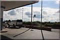
9
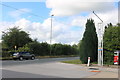
Filling station entrance on Salisbury Road
Image: © David Howard
Taken: 20 Jun 2020
0.17 miles