IMAGES TAKEN NEAR TO
Prince Of Wales Way, STOCKBRIDGE, SO20 8GS
Introduction
This page details the photographs taken nearby to Prince Of Wales Way, SO20 8GS by members of the Geograph project.
The Geograph project started in 2005 with the aim of publishing, organising and preserving representative images for every square kilometre of Great Britain, Ireland and the Isle of Man.

There are currently over 7.5m images from over14,400 individuals and you can help contribute to the project by visiting https://www.geograph.org.uk
Image Map
Images are licensed for reuse under creativecommons.org/licenses/by-sa/2.0
Notes
- Clicking on the map will re-center to the selected point.
- The higher the marker number, the further away the image location is from the centre of the postcode.
Image Listing (11 Images Found)
Images are licensed for reuse under creativecommons.org/licenses/by-sa/2.0
Image
Details
Distance
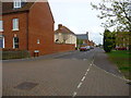
2
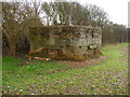
Kentsboro - Pillbox
This pillbox was most likely part of the defences of Middle Wallop airfield during WW2.
Image: © Chris Talbot
Taken: 18 Jan 2010
0.13 miles
3
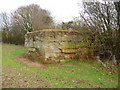
Kentsboro - Pillbox
A second World War pillbox which part of the defences of Middle Wallop Airfield.
Image: © Chris Talbot
Taken: 18 Jan 2010
0.13 miles
4
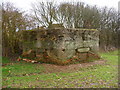
Kentsboro - Pillbox
Second World War pillbox.
Image: © Chris Talbot
Taken: 18 Jan 2010
0.13 miles
5
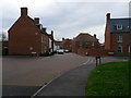
Kentsboro - Falaise Road
Military housing for those serving at Middle Wallop Airfield.
Image: © Chris Talbot
Taken: 2 Apr 2011
0.13 miles
6
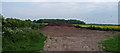
Heap of top soil
Fairly blocking the right-of-way north towards Monxton Oakcuts. Probably come from the new house building going on in Kentsboro.
Image: © Jonathan Billinger
Taken: 22 May 2008
0.20 miles
7
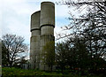
Middle Wallop - Water Tower
A fantastically shaped water tower, a masterpiece in concrete
Image: © Chris Talbot
Taken: 28 Apr 2008
0.22 miles
8

Kentsboro - Vintage Car
This 1952 Frazer Nash 2.6-Liter Prototype is one of only twelve in the world, so I was quite lucky to see it whilst filling up at the garage.
Image: © Chris Talbot
Taken: 2 Apr 2011
0.23 miles
9
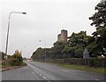
A343 from layby opposite airfield
Kentsboror' filling station in the distance. The tower on map to the right
Image: © John Firth
Taken: 17 Sep 2013
0.23 miles
10
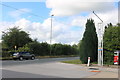
Filling station entrance on Salisbury Road
Image: © David Howard
Taken: 20 Jun 2020
0.24 miles