IMAGES TAKEN NEAR TO
Downs Close, STOCKBRIDGE, SO20 8FA
Introduction
This page details the photographs taken nearby to Downs Close, SO20 8FA by members of the Geograph project.
The Geograph project started in 2005 with the aim of publishing, organising and preserving representative images for every square kilometre of Great Britain, Ireland and the Isle of Man.

There are currently over 7.5m images from over14,400 individuals and you can help contribute to the project by visiting https://www.geograph.org.uk
Image Map (Loading...)


Getting Data...Please wait
Leaflet Map data © OpenStreetMap
Images are licensed for reuse under creativecommons.org/licenses/by-sa/2.0
Notes
- Clicking on the map will re-center to the selected point.
- The higher the marker number, the further away the image location is from the centre of the postcode.
Image Listing (20 Images Found)
Images are licensed for reuse under creativecommons.org/licenses/by-sa/2.0
Image
Details
Distance
1
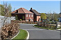
Modern housing in Downs Close, Broughton
Image: © David Martin
Taken: 17 Apr 2021
0.03 miles
2
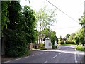
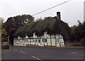
Road junctions at the northern end of Broughton
High Street curves to the left and is joined by Dixons Lane on the right and School Lane on the left, behind the white cottage.
Image: © Peter Jordan
Taken: 2 Jun 2006
0.06 miles
3
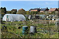
Allotments at Broughton
The modern housing beyond the allotments is in Downs Close.
Image: © David Martin
Taken: 17 Apr 2021
0.08 miles
4
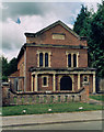
Baptist church, Broughton
This is the site of the oldest Baptist Church in Hampshire, founded 1651. The present church was in 1816. Pews are made from oak timbers salvaged from the wreck of the "Royal George" which sank off Spithead on August 29th 1782.
Image: © Peter Jordan
Taken: 2 Jun 2006
0.08 miles
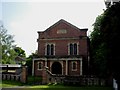
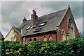
5
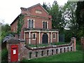
Former Broughton Baptist Chapel
Erected in 1816. Now under conversion.
Image: © Michael FORD
Taken: Unknown
0.11 miles
7
Baptist Church, Broughton
The date stone indicates a very early foundation of 1655
Image: © Tim Heaton
Taken: 9 May 2010
0.11 miles
8
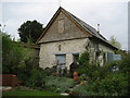
Foords Barn, Broughton
Foords Barn is the last building that remains on the site of an old village farmyard enclosed on three sides by well preserved cob walls. The barn was used as a stable in the last century, and has now been restored into self catering accommodation. A good place to stay for Clarendon Way walkers.
Image: © Chris Heaton
Taken: 9 May 2010
0.12 miles
9
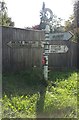
Old Direction Sign - Signpost by High Street, Broughton parish
Annulus finial - 3 arms; Hampshire Parish halo by the UC road, in parish of Broughton (Test Valley District), Broughton, at junction of High St and North End, opposite School Lane, on grass verge.
To be surveyed
Milestone Society National ID: HA_SU3033
Image: © Milestone Society
Taken: Unknown
0.13 miles
10
Former Broughton Methodist Chapel
Erected in 1910. Now converted into a private residence.
Image: © Michael FORD
Taken: Unknown
0.15 miles