IMAGES TAKEN NEAR TO
Horsebridge Road, STOCKBRIDGE, SO20 8BA
Introduction
This page details the photographs taken nearby to Horsebridge Road, SO20 8BA by members of the Geograph project.
The Geograph project started in 2005 with the aim of publishing, organising and preserving representative images for every square kilometre of Great Britain, Ireland and the Isle of Man.

There are currently over 7.5m images from over14,400 individuals and you can help contribute to the project by visiting https://www.geograph.org.uk
Image Map (Loading...)


Getting Data...Please wait
Leaflet Map data © OpenStreetMap
Images are licensed for reuse under creativecommons.org/licenses/by-sa/2.0
Notes
- Clicking on the map will re-center to the selected point.
- The higher the marker number, the further away the image location is from the centre of the postcode.
Image Listing (8 Images Found)
Images are licensed for reuse under creativecommons.org/licenses/by-sa/2.0
Image
Details
Distance

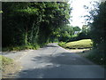
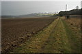
2
Arable land near Broughton
View across arable land east of Broughton.
Image: © Philip Halling
Taken: 19 Feb 2010
0.07 miles
3
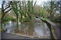
Broughton Ford
This is the second of the two fords on the Wallop Brook at Broughton.
Image: © John Walton
Taken: 23 Jan 2016
0.13 miles
4

Depth gauge in dry stream bed
The Wallop Brook is completely dry in a record-breaking dry summer.
Image: © David Martin
Taken: 18 Aug 2022
0.13 miles
5
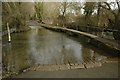
Ford near Broughton
Ford crossing Wallop Brook downstream from Broughton.
Image: © Philip Halling
Taken: 19 Feb 2010
0.15 miles
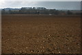
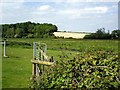
6
Headland footpath
Footpath along the broad headland to an arable field east of Broughton.
Image: © Philip Halling
Taken: 19 Feb 2010
0.20 miles
7
Wallop Brook
Wallop Brook, a tributary of the River Test. This is to the east of Broughton. The copse in the left background is in SU3132.
Image: © Peter Jordan
Taken: 2 Jun 2006
0.20 miles