IMAGES TAKEN NEAR TO
Plough Gardens, STOCKBRIDGE, SO20 8AF
Introduction
This page details the photographs taken nearby to Plough Gardens, SO20 8AF by members of the Geograph project.
The Geograph project started in 2005 with the aim of publishing, organising and preserving representative images for every square kilometre of Great Britain, Ireland and the Isle of Man.

There are currently over 7.5m images from over14,400 individuals and you can help contribute to the project by visiting https://www.geograph.org.uk
Image Map (Loading...)


Getting Data...Please wait
Leaflet Map data © OpenStreetMap
Images are licensed for reuse under creativecommons.org/licenses/by-sa/2.0
Notes
- Clicking on the map will re-center to the selected point.
- The higher the marker number, the further away the image location is from the centre of the postcode.
Image Listing (87 Images Found)
Images are licensed for reuse under creativecommons.org/licenses/by-sa/2.0
Image
Details
Distance
1
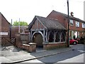
The well, High Street, Broughton
The village well has a fine shelter, but is unfortunately surrounded by less attractive buildings, including the telephone exchange to the left.
Image: © Peter Jordan
Taken: 2 Jun 2006
0.04 miles
2
Broughton - High Street
View down the high street towards St Marys Church.
Image: © Chris Talbot
Taken: 6 Apr 2008
0.04 miles
3
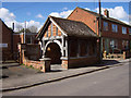
Broughton - Well
This well was given to the village by John Trude Fripp in memory of his son John who was killed in action in 1915 during the first world war at Loos France.
Image: © Chris Talbot
Taken: 6 Apr 2008
0.04 miles
4
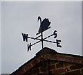
Weather vane, Broughton
For centuries weathervanes have kept people in touch with the elements, signalling those shifts in the wind, which bring changes in the weather. This simple device has grown into a charming English tradition which can say something about their owners, adding interest to the landscape.
Image: © Maigheach-gheal
Taken: 16 Aug 2008
0.05 miles
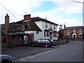
5
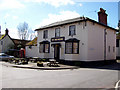
Broughton - The Greyhound Public House
The Greyhound is now closed and awaits developments.
Image: © Chris Talbot
Taken: 6 Apr 2008
0.06 miles
6
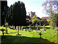
Broughton - Graveyard Of St Marys Church
St Marys has a well kept graveyard that contains burials from the 16th century as well as a rare iron grave marker that can be seen in the foreground.
Image: © Chris Talbot
Taken: 6 Apr 2008
0.06 miles
7
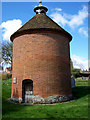
Broughton - Dovecote
The Rector of St Marys has been allowed to have a dovecote in the churchyard from around 1340, the present dovecote dates from about 1680.
Image: © Chris Talbot
Taken: 6 Apr 2008
0.06 miles
8
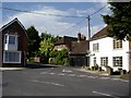
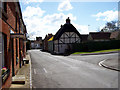
Broughton village centre
High Street cuts across the junction from the photographer and to the right of the house with the bay window. Queenwood Street joins from the right.
Image: © Peter Jordan
Taken: 2 Jun 2006
0.06 miles
10
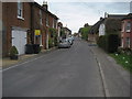
High Street, Broughton
Looking south down High Street, this photograph takes in the heart of the village.
Image: © Chris Heaton
Taken: 9 May 2010
0.07 miles