IMAGES TAKEN NEAR TO
Hayes Close, STOCKBRIDGE, SO20 6QF
Introduction
This page details the photographs taken nearby to Hayes Close, SO20 6QF by members of the Geograph project.
The Geograph project started in 2005 with the aim of publishing, organising and preserving representative images for every square kilometre of Great Britain, Ireland and the Isle of Man.

There are currently over 7.5m images from over14,400 individuals and you can help contribute to the project by visiting https://www.geograph.org.uk
Image Map (Loading...)


Getting Data...Please wait
Leaflet Map data © OpenStreetMap
Images are licensed for reuse under creativecommons.org/licenses/by-sa/2.0
Notes
- Clicking on the map will re-center to the selected point.
- The higher the marker number, the further away the image location is from the centre of the postcode.
Image Listing (174 Images Found)
Images are licensed for reuse under creativecommons.org/licenses/by-sa/2.0
Image
Details
Distance
1
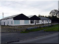
Kings Somborne - Commercial Units
These units are empty awaiting a new use.
Image: © Chris Talbot
Taken: 29 Oct 2008
0.01 miles
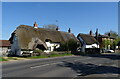
2
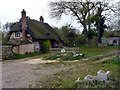
Kings Somborne - Hayes Cottage
A 16th century thatched cottage stands just off Romsey Road.
Image: © Chris Talbot
Taken: 29 Oct 2008
0.01 miles
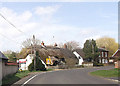
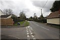
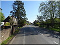
3
Into King's Somborne
Finally into King's Somborne passing some cottages on the left.
Image: © Bill Nicholls
Taken: 17 Mar 2012
0.05 miles
4
View out of King's Somborne
View out of King's Somborne looking past a small close on the left.
Image: © Bill Nicholls
Taken: 17 Mar 2012
0.05 miles
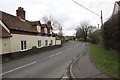
5
Thatched cottages on Romsey Road (A3057), King's Somborne
Image: © JThomas
Taken: 26 Apr 2022
0.06 miles
6
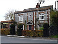
Kings Somborne - Yew Tree Cottage
This cottage is of flint with red and yellow brick, horizontal and vertical bands and a very nice clipped yew hedge.
Image: © Chris Talbot
Taken: 29 Oct 2008
0.07 miles
7
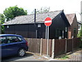
Telephone Exchange, King's Somborne
Situated off the A3057 Romsey Road, this TE serves King's Somborne, plus Houghton, Little Somborne and Up Somborne nearby. Both buildings would appear to be in use, the original TE being at the far right of the photo and dating from the GPO era, ie before 1969. The No Entry sign indicates that the road in front of the TE is one way which leads to the recreation ground and village hall, the exit being by another route. This TE has (01794) 388xxx numbers and its postcode is SO20 6PR.
Image: © David Hillas
Taken: 8 Jul 2011
0.07 miles
9
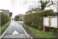
Village Hall Entrance
Entrance leading to the village hall and recreation ground in King's Somborne.
Image: © Bill Nicholls
Taken: 17 Mar 2012
0.08 miles