IMAGES TAKEN NEAR TO
Nutchers Drove, STOCKBRIDGE, SO20 6PD
Introduction
This page details the photographs taken nearby to Nutchers Drove, SO20 6PD by members of the Geograph project.
The Geograph project started in 2005 with the aim of publishing, organising and preserving representative images for every square kilometre of Great Britain, Ireland and the Isle of Man.

There are currently over 7.5m images from over14,400 individuals and you can help contribute to the project by visiting https://www.geograph.org.uk
Image Map (Loading...)


Getting Data...Please wait
Leaflet Map data © OpenStreetMap
Images are licensed for reuse under creativecommons.org/licenses/by-sa/2.0
Notes
- Clicking on the map will re-center to the selected point.
- The higher the marker number, the further away the image location is from the centre of the postcode.
Image Listing (201 Images Found)
Images are licensed for reuse under creativecommons.org/licenses/by-sa/2.0
Image
Details
Distance
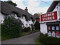
1
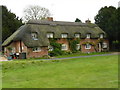
Kings Somborne - Thatches House
Thatched house.
Image: © Chris Talbot
Taken: 29 Oct 2008
0.06 miles
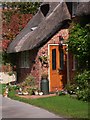
5
Muss Lane
Looking up towards the end of Muss Lane in King's Somborne.
Image: © Bill Nicholls
Taken: 17 Mar 2012
0.09 miles
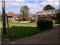
6

Footpath exit from field
This footpath at Kings Somborne leaves the field to run along behind houses.
Image: © Shazz
Taken: 25 Sep 2010
0.09 miles
7
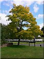
Tree in Kings Somborne
This attractive tree is at the junction of Nutcher's Drove and Old Vicarage Lane.
Image: © Shazz
Taken: 25 Sep 2010
0.10 miles
8
The south end of Muss Lane in Kings Somborne
A similar view taken four months earlier is at http://www.geograph.org.uk/photo/1865447 .
Image: © Shazz
Taken: 25 Sep 2010
0.10 miles
9
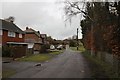
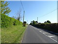
Nutchers Drove
Nutchers Drove in King's Somborne.
Image: © Bill Nicholls
Taken: 17 Mar 2012
0.11 miles
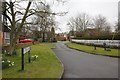
10
Stockbridge Road (A3057)
Towards Stockbridge.
Image: © JThomas
Taken: 26 Apr 2022
0.11 miles