IMAGES TAKEN NEAR TO
Broughton Road, STOCKBRIDGE, SO20 6JT
Introduction
This page details the photographs taken nearby to Broughton Road, SO20 6JT by members of the Geograph project.
The Geograph project started in 2005 with the aim of publishing, organising and preserving representative images for every square kilometre of Great Britain, Ireland and the Isle of Man.

There are currently over 7.5m images from over14,400 individuals and you can help contribute to the project by visiting https://www.geograph.org.uk
Image Map
Images are licensed for reuse under creativecommons.org/licenses/by-sa/2.0
Notes
- Clicking on the map will re-center to the selected point.
- The higher the marker number, the further away the image location is from the centre of the postcode.
Image Listing (7 Images Found)
Images are licensed for reuse under creativecommons.org/licenses/by-sa/2.0
Image
Details
Distance
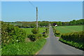
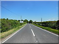
1
Broughton Road, approaching junction with the A30
Image: © David Martin
Taken: 15 Apr 2022
0.09 miles
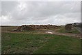
3

Crossroads at Chattis Hill
A crossroads on the A30 west of Stockbridge. The road ahead goes to Chattis Hill, the road where the photographer is standing goes to Broughton.
Image: © Peter Jordan
Taken: 14 Apr 2006
0.13 miles
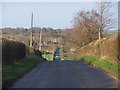
5
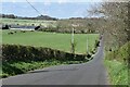
Broughton Road, looking towards Danebury
Image: © David Martin
Taken: 15 Apr 2022
0.19 miles