IMAGES TAKEN NEAR TO
Winton Hill, STOCKBRIDGE, SO20 6HJ
Introduction
This page details the photographs taken nearby to Winton Hill, SO20 6HJ by members of the Geograph project.
The Geograph project started in 2005 with the aim of publishing, organising and preserving representative images for every square kilometre of Great Britain, Ireland and the Isle of Man.

There are currently over 7.5m images from over14,400 individuals and you can help contribute to the project by visiting https://www.geograph.org.uk
Image Map (Loading...)


Getting Data...Please wait
Leaflet Map data © OpenStreetMap
Images are licensed for reuse under creativecommons.org/licenses/by-sa/2.0
Notes
- Clicking on the map will re-center to the selected point.
- The higher the marker number, the further away the image location is from the centre of the postcode.
Image Listing (2 Images Found)
Images are licensed for reuse under creativecommons.org/licenses/by-sa/2.0
Image
Details
Distance
1
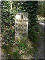
Old Milestone by the A272, Winton Lodge, Stockbridge
Metal plate attached to stone post by the A272, in parish of STOCKBRIDGE (TEST VALLEY District), Winton Lodge, at junction with drive up hill, to left of the gate way into Winton Lodge, on North side of road. Stockbridge flat-top Erected by the Stockbridge & Winchester turnpike trust in the 19th century.
Inscription reads:-
8
Miles From
WINTON
½ Mile to
STOCKBge
Carved benchmark below the plate.
Grade II listed.
List Entry Number: 1302466 https://historicengland.org.uk/listing/the-list/list-entry/1302466
Milestone Society National ID: HA_WIST08.
Image: © K Lawrence
Taken: 16 Mar 2003
0.07 miles
2
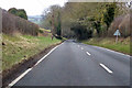
B3049 towards Stockbridge
Descending Winton Hill into the Test valley.
Image: © Robin Webster
Taken: 17 Mar 2018
0.13 miles