IMAGES TAKEN NEAR TO
Leckford, STOCKBRIDGE, SO20 6DD
Introduction
This page details the photographs taken nearby to SO20 6DD by members of the Geograph project.
The Geograph project started in 2005 with the aim of publishing, organising and preserving representative images for every square kilometre of Great Britain, Ireland and the Isle of Man.

There are currently over 7.5m images from over14,400 individuals and you can help contribute to the project by visiting https://www.geograph.org.uk
Image Map
Images are licensed for reuse under creativecommons.org/licenses/by-sa/2.0
Notes
- Clicking on the map will re-center to the selected point.
- The higher the marker number, the further away the image location is from the centre of the postcode.
Image Listing (5 Images Found)
Images are licensed for reuse under creativecommons.org/licenses/by-sa/2.0
Image
Details
Distance
1
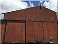
Type B1 hangar
The Type B1 hangar used in WW2 as part of RAF Chilbolton
Image: © Dave Thompson
Taken: 1 Jul 2019
0.02 miles
2
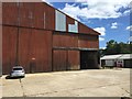
Type B1 hangar on Leckford Farm Estate
Image: © Dave Thompson
Taken: 1 Jul 2019
0.03 miles
3
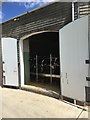
Leckford Dairy
Cattle being milked on a rotating platform
Image: © Dave Thompson
Taken: 1 Jul 2019
0.15 miles
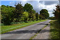
5
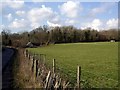
Leckford Plantation
This is the Leckford Plantation on the Leckford Estate, owned by Waitrose. Note the well-preserved pill box.
Image: © Peter Jordan
Taken: 11 Feb 2006
0.22 miles