IMAGES TAKEN NEAR TO
Cross Road, SOUTHAMPTON, SO19 4BY
Introduction
This page details the photographs taken nearby to Cross Road, SO19 4BY by members of the Geograph project.
The Geograph project started in 2005 with the aim of publishing, organising and preserving representative images for every square kilometre of Great Britain, Ireland and the Isle of Man.

There are currently over 7.5m images from over14,400 individuals and you can help contribute to the project by visiting https://www.geograph.org.uk
Image Map (Loading...)


Getting Data...Please wait
Leaflet Map data © OpenStreetMap
Images are licensed for reuse under creativecommons.org/licenses/by-sa/2.0
Notes
- Clicking on the map will re-center to the selected point.
- The higher the marker number, the further away the image location is from the centre of the postcode.
Image Listing (28 Images Found)
Images are licensed for reuse under creativecommons.org/licenses/by-sa/2.0
Image
Details
Distance
1
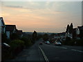
Sunset over Athelstan Road, Southampton
The sun sets on a beautiful July evening over Athelstan Road in Bitterne.
Image: © GaryReggae
Taken: 13 Jul 2005
0.06 miles
3
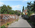
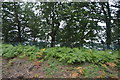
Scrawl on the Wall
The Itchen Way crosses the railway here on its short length in this square.
Image: © Des Blenkinsopp
Taken: 23 Aug 2018
0.09 miles
5
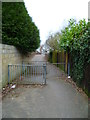
Itchen Way (26)
This path leads from Athelstan Road to Quayside Road.
Image: © Shazz
Taken: 1 Mar 2013
0.10 miles
7
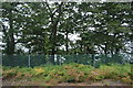
Itchen Way (28)
The path comes down from the railway bridge to reach the east end of Quayside Road.
Image: © Shazz
Taken: 1 Mar 2013
0.12 miles
8
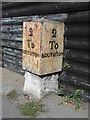
Old Milestone, A3024, Bitterne Road West, Bitterne, Southampton
The milestone is located 50m west of the junction with Juniper Road, opposite no. 292, on the pavement against corrugated iron fencing on the north side of the road. Parish of Hedge End (Eastleigh District). Metal plate attached to stone post, Botley plate design, erected by Botley turnpike trust in the 19th century.
Inscription reads:-
2 / To / SOUTHTON : : 2 / To / SOUTHTON
Milestone Society National ID: HA_SOBO02
Image: © K Lawrence
Taken: 13 Sep 2003
0.13 miles
9
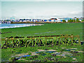
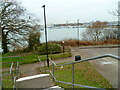
Intertidal zone, Chessel Bay
Complete with rather large debris, a steel truss, too small for a Bailey bridge, more like a bit of a tower crane.
Image: © Robin Webster
Taken: 2 Oct 2016
0.13 miles