IMAGES TAKEN NEAR TO
Bitterne Road East, SOUTHAMPTON, SO18 5QT
Introduction
This page details the photographs taken nearby to Bitterne Road East, SO18 5QT by members of the Geograph project.
The Geograph project started in 2005 with the aim of publishing, organising and preserving representative images for every square kilometre of Great Britain, Ireland and the Isle of Man.

There are currently over 7.5m images from over14,400 individuals and you can help contribute to the project by visiting https://www.geograph.org.uk
Image Map (Loading...)


Getting Data...Please wait
Leaflet Map data © OpenStreetMap
Images are licensed for reuse under creativecommons.org/licenses/by-sa/2.0
Notes
- Clicking on the map will re-center to the selected point.
- The higher the marker number, the further away the image location is from the centre of the postcode.
Image Listing (12 Images Found)
Images are licensed for reuse under creativecommons.org/licenses/by-sa/2.0
Image
Details
Distance
1
Kingdom Hall of Jehovah's Witnesses, Somerset Avenue
Image: © Basher Eyre
Taken: 29 Aug 2014
0.04 miles
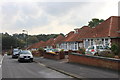
4
Barnes Road, Southampton
Viewed from Upper Deacon Road
Image: © Alex McGregor
Taken: 23 Mar 2010
0.12 miles
5
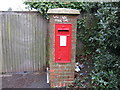
Post Box, Upper Deacon Road, Southampton
Opposite Caerleon Avenue
Image: © Alex McGregor
Taken: 23 Mar 2010
0.15 miles
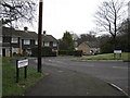
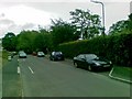
6
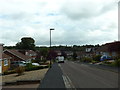
Taunton Drive in Southampton looking south-east
Image: © Roger Davies
Taken: 7 Oct 2012
0.17 miles
7
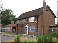
Exford Arms
Closed pub on Exford Avenue.
Image: © Oast House Archive
Taken: 29 Jun 2012
0.19 miles
9
Caerleon Avenue, Southampton
Viewed from Upper Deacon Road
Image: © Alex McGregor
Taken: 23 Mar 2010
0.21 miles
10
Looking south-east along St Elizabeth's Avenue
Image: © Basher Eyre
Taken: 29 Aug 2014
0.23 miles