IMAGES TAKEN NEAR TO
St. Gabriels Road, SOUTHAMPTON, SO18 5NA
Introduction
This page details the photographs taken nearby to St. Gabriels Road, SO18 5NA by members of the Geograph project.
The Geograph project started in 2005 with the aim of publishing, organising and preserving representative images for every square kilometre of Great Britain, Ireland and the Isle of Man.

There are currently over 7.5m images from over14,400 individuals and you can help contribute to the project by visiting https://www.geograph.org.uk
Image Map (28 Images)


Leaflet Map data © OpenStreetMap
Images are licensed for reuse under creativecommons.org/licenses/by-sa/2.0
Notes
- Clicking on the map will re-center to the selected point.
- The higher the marker number, the further away the image location is from the centre of the postcode.
Image Listing (28 Images Found)
Images are licensed for reuse under creativecommons.org/licenses/by-sa/2.0
Image
Details
Distance
1
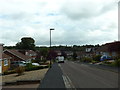
Looking south-east along St Elizabeth's Avenue
Image: © Basher Eyre
Taken: 29 Aug 2014
0.05 miles
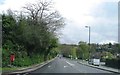
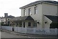
8
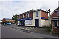
The former Percy Arms
Now a pharmacy, but it has retained the name on the wall.
Image: © Bill Boaden
Taken: 29 Sep 2016
0.15 miles
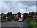
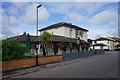
9
Humble Plumb
Probably the last pub in Southampton to serve beer direct by gravity from the cask.
http://southampton-pubs.co.uk/humbleplumb/index.htm
Image: © Graeme Wall
Taken: 19 Nov 2009
0.16 miles
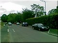
10
The Humble Plumb
A Wadworth's pub with room for a couple of guest beers. A friendly local.
Image: © Bill Boaden
Taken: 29 Sep 2016
0.16 miles