IMAGES TAKEN NEAR TO
Bitterne Road East, SOUTHAMPTON, SO18 5EG
Introduction
This page details the photographs taken nearby to Bitterne Road East, SO18 5EG by members of the Geograph project.
The Geograph project started in 2005 with the aim of publishing, organising and preserving representative images for every square kilometre of Great Britain, Ireland and the Isle of Man.

There are currently over 7.5m images from over14,400 individuals and you can help contribute to the project by visiting https://www.geograph.org.uk
Image Map (Loading...)


Getting Data...Please wait
Leaflet Map data © OpenStreetMap
Images are licensed for reuse under creativecommons.org/licenses/by-sa/2.0
Notes
- Clicking on the map will re-center to the selected point.
- The higher the marker number, the further away the image location is from the centre of the postcode.
Image Listing (50 Images Found)
Images are licensed for reuse under creativecommons.org/licenses/by-sa/2.0
Image
Details
Distance
1
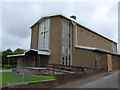
Christ the King & St Colman R.C. Church
Image: © Basher Eyre
Taken: 29 Aug 2014
0.01 miles
3
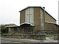
Christ the King & St Colman RC Church, Bitterne
Southampton Church
Image: © Alex McGregor
Taken: 23 Mar 2010
0.03 miles
4
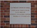
Foundation stone on the church hall in Commercial Street
Image: © Basher Eyre
Taken: 29 Aug 2014
0.03 miles
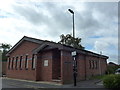
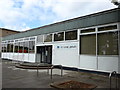
6
Bitterne Library, Southampton
Off Bitterne Road East
Image: © Alex McGregor
Taken: 23 Mar 2010
0.04 miles
7
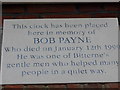
Plaque on the undertakers at the junction of Bitterne Road and Commercial Street
Image: © Basher Eyre
Taken: 29 Aug 2014
0.04 miles
8
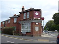
Undertakers at the junction of Bitterne Road and Commercial Street
Image: © Basher Eyre
Taken: 29 Aug 2014
0.04 miles
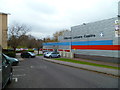
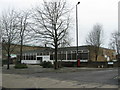
9
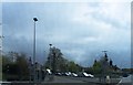
Turning into Bitterne Road East, Bitterne
Image: © Alex McGregor
Taken: 27 Apr 2012
0.05 miles