IMAGES TAKEN NEAR TO
Midanbury Lane, SOUTHAMPTON, SO18 4HP
Introduction
This page details the photographs taken nearby to Midanbury Lane, SO18 4HP by members of the Geograph project.
The Geograph project started in 2005 with the aim of publishing, organising and preserving representative images for every square kilometre of Great Britain, Ireland and the Isle of Man.

There are currently over 7.5m images from over14,400 individuals and you can help contribute to the project by visiting https://www.geograph.org.uk
Image Map
Images are licensed for reuse under creativecommons.org/licenses/by-sa/2.0
Notes
- Clicking on the map will re-center to the selected point.
- The higher the marker number, the further away the image location is from the centre of the postcode.
Image Listing (35 Images Found)
Images are licensed for reuse under creativecommons.org/licenses/by-sa/2.0
Image
Details
Distance
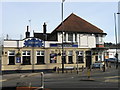
1
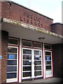
Bitterne Park Library
Beautifully 1930s.
Image: © Christopher Hilton
Taken: 11 Jan 2007
0.07 miles
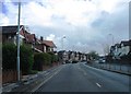
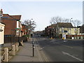
4
Bullar Road Southampton
Looking South
Image: © Alex McGregor
Taken: 22 Mar 2010
0.12 miles
5
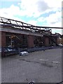
Florist and Firework Factory after fire
Image: © Alex McGregor
Taken: 23 May 2016
0.12 miles
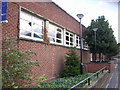
6
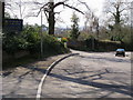
Midanbury Lane
Midanbury Lane passing St Mary's College
Image: © Shaun Ferguson
Taken: 3 Apr 2008
0.13 miles
9
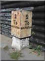
Old Milestone, A3024, Bitterne Road West, Bitterne, Southampton
The milestone is located 50m west of the junction with Juniper Road, opposite no. 292, on the pavement against corrugated iron fencing on the north side of the road. Parish of Hedge End (Eastleigh District). Metal plate attached to stone post, Botley plate design, erected by Botley turnpike trust in the 19th century.
Inscription reads:-
2 / To / SOUTHTON : : 2 / To / SOUTHTON
Milestone Society National ID: HA_SOBO02
Image: © K Lawrence
Taken: 13 Sep 2003
0.16 miles
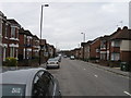
10
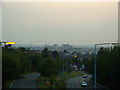
Maybray King Way, Bitterne, Southampton
Looking West along Maybray King Way, Bitterne from the Westend Road bridge. This bridge offers superb views right across the city. At the bottom of the photo, a speed camera lies in wait.
Image: © GaryReggae
Taken: 13 Jul 2005
0.17 miles