IMAGES TAKEN NEAR TO
Spinney Walk, SOUTHAMPTON, SO18 2QA
Introduction
This page details the photographs taken nearby to Spinney Walk, SO18 2QA by members of the Geograph project.
The Geograph project started in 2005 with the aim of publishing, organising and preserving representative images for every square kilometre of Great Britain, Ireland and the Isle of Man.

There are currently over 7.5m images from over14,400 individuals and you can help contribute to the project by visiting https://www.geograph.org.uk
Image Map (Loading...)


Getting Data...Please wait
Leaflet Map data © OpenStreetMap
Images are licensed for reuse under creativecommons.org/licenses/by-sa/2.0
Notes
- Clicking on the map will re-center to the selected point.
- The higher the marker number, the further away the image location is from the centre of the postcode.
Image Listing (10 Images Found)
Images are licensed for reuse under creativecommons.org/licenses/by-sa/2.0
Image
Details
Distance
1
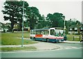
Bus in Hillgrove Road turning circle, Townhill Park
First Southampton 40629, a Dennis Dart/Alexander Dash new to Yorkshire Rider (which became part of FirstBus when its owners, Badgerline, merged with GRT), pauses in the turning circle built into the bottom of Hillgrove Road where it meets Meggeson Avenue; it is operating route 8 to Lordshill via Southampton city centre. At this time, the routes serving Townhill Park did so on a one way loop, so most buses did not bother going round the turning circle. I have fond memories of going on these buses in Leeds, so it was a pleasant surprise to find one in Southampton.
Image: © Richard Vince
Taken: 14 Mar 2006
0.13 miles
2
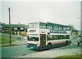
Bus on Meggeson Avenue, Townhill Park
First Southampton 34071, a long wheelbase Volvo Olympian/Northern Counties Palatine new to Stagecoach Viscount, thunders along Meggeson Avenue while traversing the Townhill Park and Midanbury loop before returning to Southampton city centre on route 3A. In an attempt to address the large number of elderly double deckers in its fleet, First had recently acquired a significant number of secondhand midlife Olympians, hence this former Stagecoach bus being part of its Southampton fleet.
Image: © Richard Vince
Taken: 14 Mar 2006
0.13 miles
3
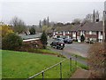
Forest Hills Drive, Townhill, Southampton
1960s housing a short way east of Woodmill Bridge. The south side of the road is built on quite a steep bank. Beyond the houses on the north side is a broad swathe of parkland along the River Itchen.
Image: © Oliver Dixon
Taken: 25 Feb 2011
0.15 miles
5
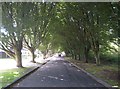
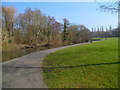
Southampton: River Walk, Townhill Park
This attractive arcade of black alder (?) trees is very much the home of the learner driver, with as many as a dozen at a time vying with another to practice reversing manoeuvres around one another. The river in question is the Itchen, off to the right here.
Image: © Nigel Cox
Taken: 20 Sep 2013
0.19 miles
6
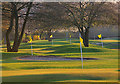
Putt Course in Riverside Park, Southampton
This park runs beside the River Itchen and happens to be exactly in line with the runway of Southampton International Airport, so you can see low flying aircraft either taking off or landing. The picture shows seven of the holes in the evening light. (Well, I had to find some use for my new 400 mm lens)
Image: © Peter Facey
Taken: 4 Apr 2007
0.20 miles
7
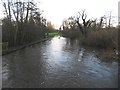
River Itchen: View from Mans Bridge
A couple of hardy canoeists paddle their way downstream early on a cold late December morning in this view from Image]
Image: © Nigel Cox
Taken: 23 Dec 2015
0.24 miles
8
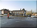
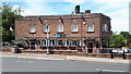
Bitterne Park, Hop Inn
Cosy, Good Beer Guide-listed pub on Oak Tree Road. Internally, traditional two-room layout, with public bar and lounge, and central horseshoe-shaped counter. Cask ales on offer at my visit: Bowman, Swift One; Flack's Double; Gale HSB; Greene King Abbot; Sharp's Doom Bar.
Image: © Mike Faherty
Taken: 31 Dec 2016
0.24 miles
10
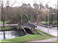
Mans Bridge, Swaythling, Southampton
Now only for feet and bicycles, this bridge once carried the main A27 trunk road traffic.
Image: © Dave Jacobs
Taken: 25 Jan 2004
0.25 miles