IMAGES TAKEN NEAR TO
Mansbridge Road, SOUTHAMPTON, SO18 2LF
Introduction
This page details the photographs taken nearby to Mansbridge Road, SO18 2LF by members of the Geograph project.
The Geograph project started in 2005 with the aim of publishing, organising and preserving representative images for every square kilometre of Great Britain, Ireland and the Isle of Man.

There are currently over 7.5m images from over14,400 individuals and you can help contribute to the project by visiting https://www.geograph.org.uk
Image Map (Loading...)


Getting Data...Please wait
Leaflet Map data © OpenStreetMap
Images are licensed for reuse under creativecommons.org/licenses/by-sa/2.0
Notes
- Clicking on the map will re-center to the selected point.
- The higher the marker number, the further away the image location is from the centre of the postcode.
Image Listing (67 Images Found)
Images are licensed for reuse under creativecommons.org/licenses/by-sa/2.0
Image
Details
Distance
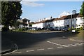
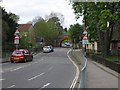
1

Roundabout on Wide Lane
Looking towards Mansbridge Road.
Image: © DS Pugh
Taken: 26 Aug 2016
0.05 miles
2
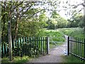
Gate into Monks Brook Greenway
Off Wide Lane, A27, near the junction with Wessex Avenue.
Image: © Robin Stott
Taken: 31 May 2011
0.05 miles
4
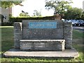
Pilgrim Place
A sign to the left reads: "Pilgrim Place / These houses and flats were built under / the provisions of the Housing Act 1924 / by the Swaythling Housing Society / a public utility society / 1925".
Image: © Robin Stott
Taken: 31 May 2011
0.05 miles
5

Path off Wide Lane
Looking along a path towards Wide Lane.
Image: © DS Pugh
Taken: 26 Aug 2016
0.06 miles
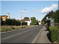
7
Wide Lane
Looking towards the low railway bridge.
Image: © Hugh Venables
Taken: 5 May 2013
0.06 miles
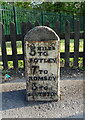

10
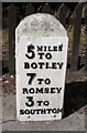
Old Milestone by the A27, Wide Lane, Swaythling
Metal plate attached to stone post by the A27, in parish of Southampton (Southampton District), Wide Lane, Swaythling; 50m West of roundabout/junction with Mansbridge Road, on pavement, on North side of road. Botley plate erected by the Botley turnpike trust in the 19th century.
Inscription reads:-
5 MILES
TO
BOTLEY
7 TO
ROMSEY
3 TO
SOUTHTON
Milestone Society National ID: HA_BORO05
Image: © Mike Faherty
Taken: 10 Jul 2010
0.07 miles