IMAGES TAKEN NEAR TO
Kingsdown Way, SOUTHAMPTON, SO18 2GQ
Introduction
This page details the photographs taken nearby to Kingsdown Way, SO18 2GQ by members of the Geograph project.
The Geograph project started in 2005 with the aim of publishing, organising and preserving representative images for every square kilometre of Great Britain, Ireland and the Isle of Man.

There are currently over 7.5m images from over14,400 individuals and you can help contribute to the project by visiting https://www.geograph.org.uk
Image Map (Loading...)


Getting Data...Please wait
Leaflet Map data © OpenStreetMap
Images are licensed for reuse under creativecommons.org/licenses/by-sa/2.0
Notes
- Clicking on the map will re-center to the selected point.
- The higher the marker number, the further away the image location is from the centre of the postcode.
Image Listing (4 Images Found)
Images are licensed for reuse under creativecommons.org/licenses/by-sa/2.0
Image
Details
Distance
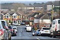
1
View down Woodmill Lane
Southampton Airport buildings in the right distance.
Image: © David Martin
Taken: 24 Dec 2019
0.21 miles
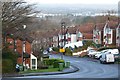
2
Woodmill Lane, Southampton
Looking North from the top of the hill (by The Castle pub) in Woodmill Lane, Townhill Park. The views from here are spectacular and it is one of the highest hills in Southampton.
Image: © GaryReggae
Taken: 13 Jul 2005
0.22 miles