IMAGES TAKEN NEAR TO
Vanguard Road, SOUTHAMPTON, SO18 2EL
Introduction
This page details the photographs taken nearby to Vanguard Road, SO18 2EL by members of the Geograph project.
The Geograph project started in 2005 with the aim of publishing, organising and preserving representative images for every square kilometre of Great Britain, Ireland and the Isle of Man.

There are currently over 7.5m images from over14,400 individuals and you can help contribute to the project by visiting https://www.geograph.org.uk
Image Map (Loading...)


Getting Data...Please wait
Leaflet Map data © OpenStreetMap
Images are licensed for reuse under creativecommons.org/licenses/by-sa/2.0
Notes
- Clicking on the map will re-center to the selected point.
- The higher the marker number, the further away the image location is from the centre of the postcode.
Image Listing (13 Images Found)
Images are licensed for reuse under creativecommons.org/licenses/by-sa/2.0
Image
Details
Distance
1
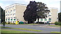
Flats in Vanguard Road
Seen across Townhill Way.
Image: © David Martin
Taken: 6 Aug 2019
0.09 miles
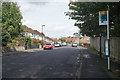
2
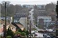
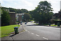
Vanguard Road from the top of Vale Drive
Image: © David Martin
Taken: 24 Dec 2019
0.09 miles
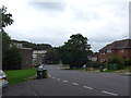
3
Vanguard Road
A mixture of high and low level housing.
Image: © Bill Boaden
Taken: 29 Sep 2016
0.10 miles
4
Mousehole Lane
Heading from Bitterne towards Bitterne Park. There are blocks of flats on the land to the left, on what for many years was the site of post-war pre-fabs.
Image: © Bill Boaden
Taken: 29 Sep 2016
0.12 miles
5
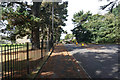
Witts Hill
A road linking Swaythling and Bitterne, passing through residential areas.
Image: © Bill Boaden
Taken: 29 Sep 2016
0.15 miles
6
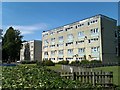
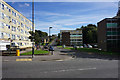
Blocks of flats, Macarthur Crescent
These are two of an estate comprising around 12 similar blocks.
Image: © David Martin
Taken: 10 Aug 2011
0.16 miles
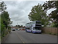
9
Wakefield Road
A residential street on a bus route.
Image: © Bill Boaden
Taken: 29 Sep 2016
0.18 miles