IMAGES TAKEN NEAR TO
Adelaide Road, SOUTHAMPTON, SO17 2HZ
Introduction
This page details the photographs taken nearby to Adelaide Road, SO17 2HZ by members of the Geograph project.
The Geograph project started in 2005 with the aim of publishing, organising and preserving representative images for every square kilometre of Great Britain, Ireland and the Isle of Man.

There are currently over 7.5m images from over14,400 individuals and you can help contribute to the project by visiting https://www.geograph.org.uk
Image Map
Images are licensed for reuse under creativecommons.org/licenses/by-sa/2.0
Notes
- Clicking on the map will re-center to the selected point.
- The higher the marker number, the further away the image location is from the centre of the postcode.
Image Listing (122 Images Found)
Images are licensed for reuse under creativecommons.org/licenses/by-sa/2.0
Image
Details
Distance
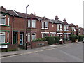
1
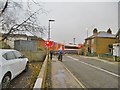
St. Denys, level crossing
Carrying Southampton to Portsmouth railway lines across Adelaide Road.
Image: © Mike Faherty
Taken: 9 Dec 2016
0.02 miles
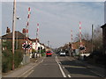
2
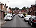
On-street parking, North Road, St Denys, Southampton
Looking towards the Adelaide Road junction.
Image: © Jaggery
Taken: 24 Aug 2016
0.02 miles
3
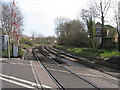
View E from Adelaide Road level crossing, St Denys, Southampton
Image: © Gareth James
Taken: 15 Mar 2011
0.03 miles
4
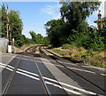
Railway across Adelaide Road, St Denys, Southampton
The level crossing is near St Denys station, 100 metres behind the camera.
Next station ahead is Woolston on the West Coastway Line towards Portsmouth.
The route was electrified (750 V DC third rail) by the Southern Railway during the interwar years.
The gap in the electrified third rails ends beyond the wooden planking.
Image: © Jaggery
Taken: 24 Aug 2016
0.03 miles
5
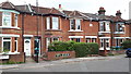
Terraced houses in Adelaide Road
This terrace is named Shamrock Villas.
Image: © David Martin
Taken: 8 Aug 2019
0.03 miles
6
Adelaide Road level crossing, St Denys, Southampton
Image: © Gareth James
Taken: 15 Mar 2011
0.03 miles
7
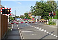
Barriers down across Adelaide Road level crossing, St Denys, Southampton
The road is blocked - a train is imminent. The level crossing is 100 metres NE of St Denys railway station.
Image: © Jaggery
Taken: 24 Aug 2016
0.03 miles
8
Shamrock Villas, Adelaide Road, St Denys, Southampton
Viewed from the corner of North Road. The address above the green door on the left is 1 SHAMROCK VILLAS. SHAMROCK VILLAS is engraved on the wall near a satellite dish.
Image: © Jaggery
Taken: 24 Aug 2016
0.04 miles
9
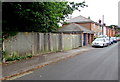
North Road electricity substation, St Denys, Southampton
The SSE Power Distribution electricity substation is behind the long wooden fence.
Image: © Jaggery
Taken: 24 Aug 2016
0.04 miles
10
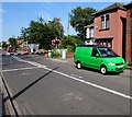
Vivid green van in St Denys, Southampton
Parked in Adelaide Road on the south side of a level crossing. http://www.geograph.org.uk/photo/5092450
Image: © Jaggery
Taken: 24 Aug 2016
0.04 miles