IMAGES TAKEN NEAR TO
Cranford Way, SOUTHAMPTON, SO17 1RN
Introduction
This page details the photographs taken nearby to Cranford Way, SO17 1RN by members of the Geograph project.
The Geograph project started in 2005 with the aim of publishing, organising and preserving representative images for every square kilometre of Great Britain, Ireland and the Isle of Man.

There are currently over 7.5m images from over14,400 individuals and you can help contribute to the project by visiting https://www.geograph.org.uk
Image Map
Images are licensed for reuse under creativecommons.org/licenses/by-sa/2.0
Notes
- Clicking on the map will re-center to the selected point.
- The higher the marker number, the further away the image location is from the centre of the postcode.
Image Listing (45 Images Found)
Images are licensed for reuse under creativecommons.org/licenses/by-sa/2.0
Image
Details
Distance

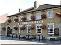
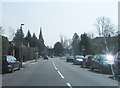
3
Highfield Pub
with a small group of shops beyond (post office sign can just be seen).
Image: © Hugh Venables
Taken: 4 Feb 2007
0.09 miles
4
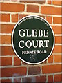
Glebe Court
the plaque on the gates says this development is from 1928.
Image: © Hugh Venables
Taken: 4 Feb 2007
0.10 miles
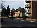
7
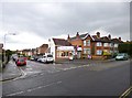
Highfield News
Newsagent on the corner of Highfield Lane and Heatherdeane Road.
Image: © Mike Faherty
Taken: 19 Apr 2012
0.11 miles
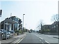
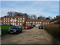
9
Parkside, 51 Highfield Lane (corner with Roselands Gardens)
Image: © Nichola Caveney
Taken: 2 Oct 2008
0.11 miles
